Anvin geodata
Anvin (Hauts-de-France) is a populated place; located in France in Europe/Paris (GMT+2) time zone. With population of 759 people, there are 11065 cities with bigger population in this country. Compared to other cities in France, 96.8% of cities are located further ↓South; 53.4% of cities are located further →East and 77.8% of cities have higher elevation than Anvin. Note1
Administrative division(s):
- Level 1: Hauts-de-France
- Level 2: Pas-de-Calais
- Level 3: Arras
- Level 4: Anvin


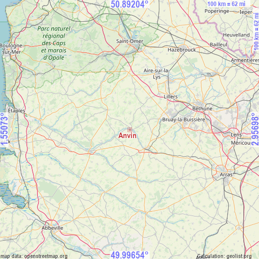
Anvin GPS coordinates[2]
50° 26' 47.076" North, 2° 15' 13.896" East
| Map corner | latitude | longitude |
|---|---|---|
| Upper-left | 50.89204°, | 1.55073° |
| Center: | 50.44641°, | 2.25386° |
| Lower-right: | 49.99654°, | 2.95698° |
| Map W x H: | 99.6×99.6 km | = 61.9×61.9mi |
| max Lat: | 51.07786° ⇑3.2% North |
| Anvin: | 50.44641° |
| min Lat: | ⇓96.8% South 41.3874° |
| min Long | Anvin | max Long |
| -5.08615° | 2.25386° | 9.52242° |
| W 46.6%⇐ | ⇒53.4% E |
Elevation
Elevation of Anvin is 60 m = 197 ft, and this is 133.7 m = 439 ft below average elevation for this country.
| Max E: |
2333 m = 7654 ft | 77.8% |
| Avg. | 193.7 m = 635 ft | |
| Anvin | 60 m = 197 ft | |
Min E: |
-1 m = -3 ft | 22.2% |
See also: France elevation on elevation.city.
Geographical zone
Anvin is located in North temperate zone (between Tropic of Cancer and the Arctic Circle). Distance of this North polar circle is 1792.1 km =1113.6 mi to North.| Distance of | km | miles | from Anvin |
|---|---|---|---|
| North Pole | 4397.9 | 2732.7 | to North |
| Arctic Circle | 1792.1 | 1113.6 | to North |
| Tropic Cancer | 3003.2 | 1866.1 | to South |
| Equator | 5609.1 | 3485.3 | to South |


Nearby cities:
15 places around Anvin: (largest is in red/bold)
• Auchy-lès-Hesdin
11.9 km =7.4 mi,  245°
245°
• Blangy-sur-Ternoise
6.6 km =4.1 mi, 245°
• Bours
11 km =6.8 mi,  85°
85°
• Diéval
13.9 km =8.6 mi,  95°
95°
• Febvin-Palfart
11.1 km =6.9 mi,  23°
23°
• Floringhem
13.3 km =8.3 mi,  65°
65°
• Fruges
11.5 km =7.1 mi,  311°
311°
• Gauchin-Verloingt
7 km =4.3 mi,  143°
143°
• Heuchin
3.4 km =2.1 mi, 18°
• Le Parcq
13.4 km =8.3 mi,  235°
235°
• Lisbourg
7.2 km =4.5 mi,  338°
338°
• Pernes
12 km =7.5 mi, 69°
• Roëllecourt
12.8 km =8 mi,  132°
132°
• Saint-Pol-sur-Ternoise
9.2 km =5.7 mi, 141°
• Valhuon
8.9 km =5.5 mi, 99°
Sources, notices
• [Note1] Compared only with cities in France existing in our database
• [Src1] Map data: © OpenStreetMap contributors (CC-BY-SA)
• [Src2] Other city data from geonames.org with taken over terms of usage.
• [Src3] Geographical zone / Annual Mean Temperature by Robert A. Rohde @ Wikipedia
