Gauchin-Verloingt geodata
Gauchin-Verloingt (Hauts-de-France) is a populated place; located in France in Europe/Paris (GMT+2) time zone. With population of 854 people, there are 10043 cities with bigger population in this country. Compared to other cities in France, 96.4% of cities are located further ↓South; 52.5% of cities are located further →East and 67.4% of cities have higher elevation than Gauchin-Verloingt. Note1
Administrative division(s):
- Level 1: Hauts-de-France
- Level 2: Pas-de-Calais
- Level 3: Arras
- Level 4: Gauchin-Verloingt


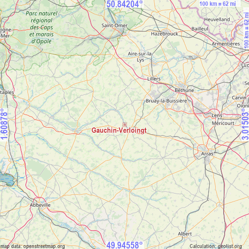
Gauchin-Verloingt GPS coordinates[2]
50° 23' 45.348" North, 2° 18' 42.84" East
| Map corner | latitude | longitude |
|---|---|---|
| Upper-left | 50.84204°, | 1.60878° |
| Center: | 50.39593°, | 2.3119° |
| Lower-right: | 49.94558°, | 3.01503° |
| Map W x H: | 99.7×99.7 km | = 62×62mi |
| max Lat: | 51.07786° ⇑3.6% North |
| Gauchin-Verloingt: | 50.39593° |
| min Lat: | ⇓96.4% South 41.3874° |
| min Long | Gauchin-Verloin | max Long |
| -5.08615° | 2.3119° | 9.52242° |
| W 47.5%⇐ | ⇒52.5% E |
Elevation
Elevation of Gauchin-Verloingt is 84 m = 276 ft, and this is 109.7 m = 360 ft below average elevation for this country.
| Max E: |
2333 m = 7654 ft | 67.4% |
| Avg. | 193.7 m = 635 ft | |
| Gauchin-Verloingt | 84 m = 276 ft | |
Min E: |
-1 m = -3 ft | 32.6% |
See also: France elevation on elevation.city.
Geographical zone
Gauchin-Verloingt is located in North temperate zone (between Tropic of Cancer and the Arctic Circle). Distance of this North polar circle is 1797.7 km =1117 mi to North.| Distance of | km | miles | from Gauchin-Verloingt |
|---|---|---|---|
| North Pole | 4403.6 | 2736.3 | to North |
| Arctic Circle | 1797.7 | 1117 | to North |
| Tropic Cancer | 2997.6 | 1862.6 | to South |
| Equator | 5603.5 | 3481.9 | to South |


Nearby cities:
15 places around Gauchin-Verloingt: (largest is in red/bold)
• Anvin
7 km =4.3 mi,  323°
323°
• Blangy-sur-Ternoise
10.5 km =6.5 mi,  285°
285°
• Boubers-sur-Canche
12.9 km =8 mi,  204°
204°
• Bours
9.4 km =5.8 mi,  47°
47°
• Diéval
10.7 km =6.6 mi,  65°
65°
• Floringhem
13.7 km =8.5 mi,  35°
35°
• Frévent
13.4 km =8.3 mi,  187°
187°
• Heuchin
9.3 km =5.8 mi,  341°
341°
• La Comté
13.2 km =8.2 mi,  75°
75°
• Magnicourt-en-Comte
13.3 km =8.3 mi,  88°
88°
• Pernes
12.1 km =7.5 mi, 35°
• Roëllecourt
6.1 km =3.8 mi,  120°
120°
• Saint-Pol-sur-Ternoise
2.3 km =1.4 mi,  136°
136°
• Tincques
13.5 km =8.4 mi,  107°
107°
• Valhuon
6.3 km =3.9 mi, 48°
Sources, notices
• [Note1] Compared only with cities in France existing in our database
• [Src1] Map data: © OpenStreetMap contributors (CC-BY-SA)
• [Src2] Other city data from geonames.org with taken over terms of usage.
• [Src3] Geographical zone / Annual Mean Temperature by Robert A. Rohde @ Wikipedia
