Fruges geodata
Fruges (Hauts-de-France) is a populated place; located in France in Europe/Paris (GMT+2) time zone. With population of 2,862 people, there are 3409 cities with bigger population in this country. Compared to other cities in France, 97.4% of cities are located further ↓South; 55.4% of cities are located further →East and 60.4% of cities have higher elevation than Fruges. Note1
Administrative division(s):
- Level 1: Hauts-de-France
- Level 2: Pas-de-Calais
- Level 3: Arrondissement de Montreuil
- Level 4: Fruges


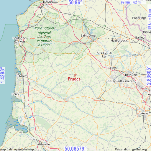
Fruges GPS coordinates[2]
50° 30' 54.036" North, 2° 7' 58.512" East
| Map corner | latitude | longitude |
|---|---|---|
| Upper-left | 50.96°, | 1.4298° |
| Center: | 50.51501°, | 2.13292° |
| Lower-right: | 50.06579°, | 2.83605° |
| Map W x H: | 99.4×99.4 km | = 61.8×61.8mi |
| max Lat: | 51.07786° ⇑2.6% North |
| Fruges: | 50.51501° |
| min Lat: | ⇓97.4% South 41.3874° |
| min Long | Fruges | max Long |
| -5.08615° | 2.13292° | 9.52242° |
| W 44.6%⇐ | ⇒55.4% E |
Elevation
Elevation of Fruges is 101 m = 331 ft, and this is 92.7 m = 304 ft below average elevation for this country.
| Max E: |
2333 m = 7654 ft | 60.4% |
| Avg. | 193.7 m = 635 ft | |
| Fruges | 101 m = 331 ft | |
Min E: |
-1 m = -3 ft | 39.6% |
See also: France elevation on elevation.city.
Geographical zone
Fruges is located in North temperate zone (between Tropic of Cancer and the Arctic Circle). Distance of this North polar circle is 1784.4 km =1108.8 mi to North.| Distance of | km | miles | from Fruges |
|---|---|---|---|
| North Pole | 4390.3 | 2728 | to North |
| Arctic Circle | 1784.4 | 1108.8 | to North |
| Tropic Cancer | 3010.8 | 1870.8 | to South |
| Equator | 5616.7 | 3490.1 | to South |


Nearby cities:
15 places around Fruges: (largest is in red/bold)
• Anvin
11.5 km =7.1 mi,  131°
131°
• Audincthun
7.6 km =4.7 mi,  0°
0°
• Blangy-sur-Ternoise
10.7 km =6.6 mi,  166°
166°
• Bomy
9.7 km =6 mi,  47°
47°
• Coupelle-Vieille
2.6 km =1.6 mi,  292°
292°
• Coyecques
10.5 km =6.5 mi,  19°
19°
• Créquy
6 km =3.7 mi,  246°
246°
• Delettes
12.7 km =7.9 mi,  26°
26°
• Fauquembergues
9.8 km =6.1 mi,  345°
345°
• Fressin
9.3 km =5.8 mi,  219°
219°
• Heuchin
10.6 km =6.6 mi,  114°
114°
• Lisbourg
6 km =3.7 mi,  98°
98°
• Merck-Saint-Liévin
12.3 km =7.6 mi, 354°
• Verchocq
8.5 km =5.3 mi,  309°
309°
• Wailly
4.7 km =2.9 mi,  280°
280°
Sources, notices
• [Note1] Compared only with cities in France existing in our database
• [Src1] Map data: © OpenStreetMap contributors (CC-BY-SA)
• [Src2] Other city data from geonames.org with taken over terms of usage.
• [Src3] Geographical zone / Annual Mean Temperature by Robert A. Rohde @ Wikipedia
