Sainte-Foy-Tarentaise geodata
Sainte-Foy-Tarentaise (Auvergne-Rhône-Alpes) is a populated place; located in France in Europe/Paris (GMT+2) time zone. With population of 736 people, there are 11334 cities with bigger population in this country. Compared to other cities in France, 72.7% of cities are located further ↑North; 94.2% of cities are located further ←West and 99.8% of cities have lower elevation than Sainte-Foy-Tarentaise. Note1
Administrative division(s):
- Level 1: Auvergne-Rhône-Alpes
- Level 2: Savoie
- Level 3: Albertville
- Level 4: Sainte-Foy-Tarentaise
Current local time in Sainte-Foy-Tarentaise:
03:12 PM, WednesdayDifference from your time zone: hours


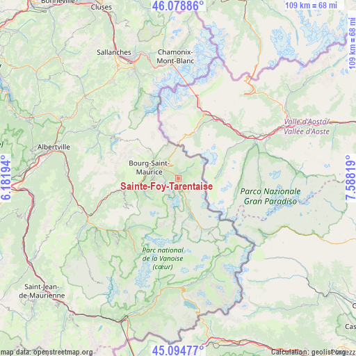
Sainte-Foy-Tarentaise GPS coordinates[2]
45° 35' 20.292" North, 6° 53' 6.216" East
| Map corner | latitude | longitude |
|---|---|---|
| Upper-left | 46.07886°, | 6.18194° |
| Center: | 45.58897°, | 6.88506° |
| Lower-right: | 45.09477°, | 7.58819° |
| Map W x H: | 109.4×109.4 km | = 68×68mi |
| max Lat: | 51.07786° ⇑72.7% North |
| Sainte-Foy-Tarentaise: | 45.58897° |
| min Lat: | ⇓27.3% South 41.3874° |
| min Long | Sainte-Foy-Tare | max Long |
| -5.08615° | 6.88506° | 9.52242° |
| W 94.2%⇐ | ⇒5.8% E |
Elevation
Elevation of Sainte-Foy-Tarentaise is 1422 m = 4665 ft, and this is 1228.3 m = 4030 ft above average elevation for this country.
| Max E: |
2333 m = 7654 ft | 0.2% |
| Sainte-Foy-Tarentaise | 1422 m 4665 ft | |
| Avg. | 193.7 m = 635 ft | |
Min E: |
-1 m = -3 ft | 99.8% |
See also: France elevation on elevation.city.
Geographical zone
Sainte-Foy-Tarentaise is located in North temperate zone (between Tropic of Cancer and the Arctic Circle). Distance of this North polar circle is 2332.2 km =1449.2 mi to North.| Distance of | km | miles | from Sainte-Foy-Tarentaise |
|---|---|---|---|
| North Pole | 4938 | 3068.3 | to North |
| Arctic Circle | 2332.2 | 1449.2 | to North |
| Tropic Cancer | 2463.1 | 1530.5 | to South |
| Equator | 5069 | 3149.7 | to South |


Nearby cities:
15 places around Sainte-Foy-Tarentaise: (largest is in red/bold)
• Aime
18.6 km =11.6 mi,  258°
258°
• Belle-Plagne
16.5 km =10.3 mi,  237°
237°
• Bellentre
13.5 km =8.4 mi, 260°
• Bourg-Saint-Maurice
9.5 km =5.9 mi,  287°
287°
• Bozel
24.5 km =15.2 mi,  228°
228°
• Champagny-en-Vanoise
21.1 km =13.1 mi,  224°
224°
• Landry
11.5 km =7.1 mi, 260°
• Montvalezan
3.9 km =2.4 mi,  309°
309°
• Mâcot-la-Plagne
17.5 km =10.9 mi, 255°
• Peisey-Nancroix
11.1 km =6.9 mi, 244°
• Pralognan-la-Vanoise
26.3 km =16.3 mi,  209°
209°
• Saint-Bon-Tarentaise
25.9 km =16.1 mi, 228°
• Séez
7.6 km =4.7 mi,  300°
300°
• Tignes
10.8 km =6.7 mi,  163°
163°
• Val-d’Isère
16.8 km =10.4 mi, 155°
Sources, notices
• [Note1] Compared only with cities in France existing in our database
• [Src1] Map data: © OpenStreetMap contributors (CC-BY-SA)
• [Src2] Other city data from geonames.org with taken over terms of usage.
• [Src3] Geographical zone / Annual Mean Temperature by Robert A. Rohde @ Wikipedia
