Belhomert-Guéhouville geodata
Belhomert-Guéhouville (Centre) is a populated place; located in France in Europe/Paris (GMT+2) time zone. With population of 780 people, there are 10827 cities with bigger population in this country. Compared to other cities in France, 68.4% of cities are located further ↓South; 68.2% of cities are located further →East and 67% of cities have lower elevation than Belhomert-Guéhouville. Note1
Administrative division(s):
- Level 1: Centre
- Level 2: Département d'Eure-et-Loir
- Level 3: Arrondissement de Nogent-le-Rotrou
- Level 4: Belhomert-Guéhouville
Current local time in Belhomert-Guéhouville:
11:29 AM, SaturdayDifference from your time zone: hours


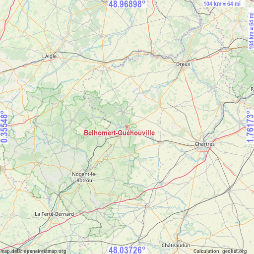
Belhomert-Guéhouville GPS coordinates[2]
48° 30' 18.936" North, 1° 3' 30.96" East
| Map corner | latitude | longitude |
|---|---|---|
| Upper-left | 48.96898°, | 0.35548° |
| Center: | 48.50526°, | 1.0586° |
| Lower-right: | 48.03726°, | 1.76173° |
| Map W x H: | 103.6×103.6 km | = 64.4×64.4mi |
| max Lat: | 51.07786° ⇑31.6% North |
| Belhomert-Guéhouville: | 48.50526° |
| min Lat: | ⇓68.4% South 41.3874° |
| min Long | Belhomert-Guéh | max Long |
| -5.08615° | 1.0586° | 9.52242° |
| W 31.8%⇐ | ⇒68.2% E |
Elevation
Elevation of Belhomert-Guéhouville is 204 m = 669 ft, and this is 10.3 m = 34 ft above average elevation for this country.
| Max E: |
2333 m = 7654 ft | 33% |
| Belhomert-Guéhouville | 204 m 669 ft | |
| Avg. | 193.7 m = 635 ft | |
Min E: |
-1 m = -3 ft | 67% |
See also: France elevation on elevation.city.
Geographical zone
Belhomert-Guéhouville is located in North temperate zone (between Tropic of Cancer and the Arctic Circle). Distance of this North polar circle is 2007.9 km =1247.7 mi to North.| Distance of | km | miles | from Belhomert-Guéhouville |
|---|---|---|---|
| North Pole | 4613.8 | 2866.9 | to North |
| Arctic Circle | 2007.9 | 1247.7 | to North |
| Tropic Cancer | 2787.4 | 1732 | to South |
| Equator | 5393.3 | 3351.2 | to South |


Nearby cities:
15 places around Belhomert-Guéhouville: (largest is in red/bold)
• Bretoncelles
15 km =9.3 mi,  236°
236°
• Chuisnes
12.7 km =7.9 mi,  120°
120°
• Courville-sur-Eure
14.8 km =9.2 mi,  114°
114°
• Digny
7.8 km =4.8 mi,  63°
63°
• Fontaine-Simon
2.9 km =1.8 mi,  267°
267°
• La Loupe
4.8 km =3 mi,  221°
221°
• Landelles
11.1 km =6.9 mi, 112°
• Manou
6 km =3.7 mi,  285°
285°
• Meaucé
4.6 km =2.9 mi, 243°
• Neuilly-sur-Eure
12.1 km =7.5 mi, 289°
• Pontgouin
7.9 km =4.9 mi, 109°
• Saint-Arnoult-des-Bois
15.2 km =9.4 mi,  95°
95°
• Saint-Maurice-Saint-Germain
1.7 km =1.1 mi, 122°
• Saint-Éliph
6.5 km =4 mi,  201°
201°
• Senonches
6.4 km =4 mi,  341°
341°
Sources, notices
• [Note1] Compared only with cities in France existing in our database
• [Src1] Map data: © OpenStreetMap contributors (CC-BY-SA)
• [Src2] Other city data from geonames.org with taken over terms of usage.
• [Src3] Geographical zone / Annual Mean Temperature by Robert A. Rohde @ Wikipedia
