Bretoncelles geodata
Bretoncelles (Normandy) is a populated place; located in France in Europe/Paris (GMT+2) time zone. With population of 1,367 people, there are 6735 cities with bigger population in this country. Compared to other cities in France, 66.9% of cities are located further ↓South; 69.9% of cities are located further →East and 56.3% of cities have lower elevation than Bretoncelles. Note1
Administrative division(s):
- Level 1: Normandy
- Level 2: Département de l'Orne
- Level 3: Arrondissement de Mortagne-au-Perche
- Level 4: Bretoncelles


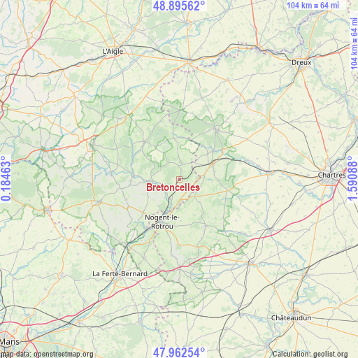
Bretoncelles GPS coordinates[2]
48° 25' 52.392" North, 0° 53' 15.9" East
| Map corner | latitude | longitude |
|---|---|---|
| Upper-left | 48.89562°, | 0.18463° |
| Center: | 48.43122°, | 0.88775° |
| Lower-right: | 47.96254°, | 1.59088° |
| Map W x H: | 103.7×103.7 km | = 64.4×64.4mi |
| max Lat: | 51.07786° ⇑33.1% North |
| Bretoncelles: | 48.43122° |
| min Lat: | ⇓66.9% South 41.3874° |
| min Long | Bretoncelles | max Long |
| -5.08615° | 0.88775° | 9.52242° |
| W 30.1%⇐ | ⇒69.9% E |
Elevation
Elevation of Bretoncelles is 155 m = 509 ft, and this is 38.7 m = 127 ft below average elevation for this country.
| Max E: |
2333 m = 7654 ft | 43.7% |
| Avg. | 193.7 m = 635 ft | |
| Bretoncelles | 155 m = 509 ft | |
Min E: |
-1 m = -3 ft | 56.3% |
See also: France elevation on elevation.city.
Geographical zone
Bretoncelles is located in North temperate zone (between Tropic of Cancer and the Arctic Circle). Distance of this North polar circle is 2016.1 km =1252.7 mi to North.| Distance of | km | miles | from Bretoncelles |
|---|---|---|---|
| North Pole | 4622 | 2872 | to North |
| Arctic Circle | 2016.1 | 1252.7 | to North |
| Tropic Cancer | 2779.1 | 1726.9 | to South |
| Equator | 5385 | 3346.1 | to South |


Nearby cities:
15 places around Bretoncelles: (largest is in red/bold)
• Belhomert-Guéhouville
15 km =9.3 mi,  56°
56°
• Brunelles
11.9 km =7.4 mi,  178°
178°
• Condé-sur-Huisne
6.2 km =3.9 mi,  205°
205°
• Fontaine-Simon
12.6 km =7.8 mi,  50°
50°
• La Loupe
10.5 km =6.5 mi, 63°
• Longny-au-Perche
14.8 km =9.2 mi,  317°
317°
• Manou
11.9 km =7.4 mi,  34°
34°
• Margon
11.3 km =7 mi,  200°
200°
• Meaucé
10.5 km =6.5 mi, 54°
• Moutiers-au-Perche
6 km =3.7 mi,  328°
328°
• Neuilly-sur-Eure
12.4 km =7.7 mi,  5°
5°
• Nogent-le-Rotrou
13.1 km =8.1 mi, 201°
• Rémalard
8.6 km =5.3 mi,  268°
268°
• Saint-Éliph
10.4 km =6.5 mi,  77°
77°
• Thiron Gardais
14.6 km =9.1 mi,  151°
151°
Sources, notices
• [Note1] Compared only with cities in France existing in our database
• [Src1] Map data: © OpenStreetMap contributors (CC-BY-SA)
• [Src2] Other city data from geonames.org with taken over terms of usage.
• [Src3] Geographical zone / Annual Mean Temperature by Robert A. Rohde @ Wikipedia
