Neuilly-sur-Eure geodata
Neuilly-sur-Eure (Normandy) is a populated place; located in France in Europe/Paris (GMT+2) time zone. With population of 508 people, there are 15076 cities with bigger population in this country. Compared to other cities in France, 69.3% of cities are located further ↓South; 69.7% of cities are located further →East and 69.8% of cities have lower elevation than Neuilly-sur-Eure. Note1
Administrative division(s):
- Level 1: Normandy
- Level 2: Département de l'Orne
- Level 3: Arrondissement de Mortagne-au-Perche
- Level 4: Longny les Villages


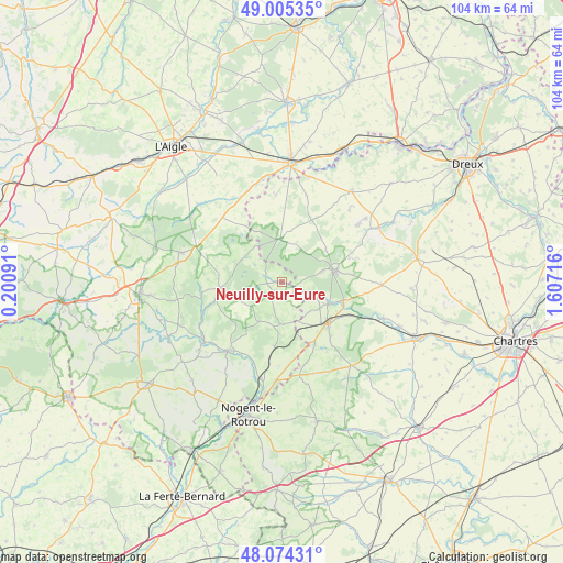
Neuilly-sur-Eure GPS coordinates[2]
48° 32' 31.092" North, 0° 54' 14.508" East
| Map corner | latitude | longitude |
|---|---|---|
| Upper-left | 49.00535°, | 0.20091° |
| Center: | 48.54197°, | 0.90403° |
| Lower-right: | 48.07431°, | 1.60716° |
| Map W x H: | 103.5×103.5 km | = 64.3×64.3mi |
| max Lat: | 51.07786° ⇑30.7% North |
| Neuilly-sur-Eure: | 48.54197° |
| min Lat: | ⇓69.3% South 41.3874° |
| min Long | Neuilly-sur-Eur | max Long |
| -5.08615° | 0.90403° | 9.52242° |
| W 30.3%⇐ | ⇒69.7% E |
Elevation
Elevation of Neuilly-sur-Eure is 218 m = 715 ft, and this is 24.3 m = 80 ft above average elevation for this country.
| Max E: |
2333 m = 7654 ft | 30.2% |
| Neuilly-sur-Eure | 218 m 715 ft | |
| Avg. | 193.7 m = 635 ft | |
Min E: |
-1 m = -3 ft | 69.8% |
See also: France elevation on elevation.city.
Geographical zone
Neuilly-sur-Eure is located in North temperate zone (between Tropic of Cancer and the Arctic Circle). Distance of this North polar circle is 2003.8 km =1245.1 mi to North.| Distance of | km | miles | from Neuilly-sur-Eure |
|---|---|---|---|
| North Pole | 4609.7 | 2864.3 | to North |
| Arctic Circle | 2003.8 | 1245.1 | to North |
| Tropic Cancer | 2791.4 | 1734.5 | to South |
| Equator | 5397.4 | 3353.8 | to South |


Nearby cities:
15 places around Neuilly-sur-Eure: (largest is in red/bold)
• Belhomert-Guéhouville
12.1 km =7.5 mi,  109°
109°
• Boissy-lès-Perche
16 km =9.9 mi,  356°
356°
• Bretoncelles
12.4 km =7.7 mi,  185°
185°
• Fontaine-Simon
9.5 km =5.9 mi,  116°
116°
• La Ferté-Vidame
7.7 km =4.8 mi, 358°
• La Loupe
11.2 km =7 mi,  132°
132°
• Longny-au-Perche
11.2 km =7 mi,  263°
263°
• Manou
6.1 km =3.8 mi, 114°
• Meaucé
9.6 km =6 mi, 130°
• Moutiers-au-Perche
8.4 km =5.2 mi,  210°
210°
• Rémalard
15.9 km =9.9 mi,  217°
217°
• Saint-Maurice-Saint-Germain
13.7 km =8.5 mi, 111°
• Saint-Maurice-lès-Charencey
16 km =9.9 mi,  317°
317°
• Saint-Éliph
13.5 km =8.4 mi,  138°
138°
• Senonches
9.5 km =5.9 mi,  77°
77°
Sources, notices
• [Note1] Compared only with cities in France existing in our database
• [Src1] Map data: © OpenStreetMap contributors (CC-BY-SA)
• [Src2] Other city data from geonames.org with taken over terms of usage.
• [Src3] Geographical zone / Annual Mean Temperature by Robert A. Rohde @ Wikipedia
