Manou geodata
Manou (Centre) is a populated place; located in France in Europe/Paris (GMT+2) time zone. With population of 589 people, there are 13496 cities with bigger population in this country. Compared to other cities in France, 68.8% of cities are located further ↓South; 69% of cities are located further →East and 67.6% of cities have lower elevation than Manou. Note1
Administrative division(s):
- Level 1: Centre
- Level 2: Département d'Eure-et-Loir
- Level 3: Arrondissement de Nogent-le-Rotrou
- Level 4: Manou


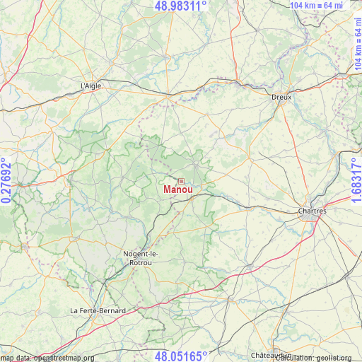
Manou GPS coordinates[2]
48° 31' 10.272" North, 0° 58' 48.144" East
| Map corner | latitude | longitude |
|---|---|---|
| Upper-left | 48.98311°, | 0.27692° |
| Center: | 48.51952°, | 0.98004° |
| Lower-right: | 48.05165°, | 1.68317° |
| Map W x H: | 103.6×103.6 km | = 64.4×64.4mi |
| max Lat: | 51.07786° ⇑31.2% North |
| Manou: | 48.51952° |
| min Lat: | ⇓68.8% South 41.3874° |
| min Long | Manou | max Long |
| -5.08615° | 0.98004° | 9.52242° |
| W 31%⇐ | ⇒69% E |
Elevation
Elevation of Manou is 207 m = 679 ft, and this is 13.3 m = 44 ft above average elevation for this country.
| Max E: |
2333 m = 7654 ft | 32.4% |
| Manou | 207 m 679 ft | |
| Avg. | 193.7 m = 635 ft | |
Min E: |
-1 m = -3 ft | 67.6% |
See also: France elevation on elevation.city.
Geographical zone
Manou is located in North temperate zone (between Tropic of Cancer and the Arctic Circle). Distance of this North polar circle is 2006.3 km =1246.7 mi to North.| Distance of | km | miles | from Manou |
|---|---|---|---|
| North Pole | 4612.2 | 2865.9 | to North |
| Arctic Circle | 2006.3 | 1246.7 | to North |
| Tropic Cancer | 2788.9 | 1732.9 | to South |
| Equator | 5394.9 | 3352.2 | to South |


Nearby cities:
15 places around Manou: (largest is in red/bold)
• Belhomert-Guéhouville
6 km =3.7 mi,  105°
105°
• Bretoncelles
11.9 km =7.4 mi,  214°
214°
• Digny
12.9 km =8 mi,  81°
81°
• Fontaine-Simon
3.3 km =2.1 mi,  120°
120°
• La Ferté-Vidame
11.8 km =7.3 mi,  330°
330°
• La Loupe
5.8 km =3.6 mi,  152°
152°
• Landelles
17 km =10.6 mi, 109°
• Longny-au-Perche
16.8 km =10.4 mi,  273°
273°
• Meaucé
4 km =2.5 mi, 154°
• Moutiers-au-Perche
10.9 km =6.8 mi,  244°
244°
• Neuilly-sur-Eure
6.1 km =3.8 mi,  294°
294°
• Pontgouin
13.9 km =8.6 mi, 107°
• Saint-Maurice-Saint-Germain
7.6 km =4.7 mi, 109°
• Saint-Éliph
8.3 km =5.2 mi,  156°
156°
• Senonches
5.8 km =3.6 mi,  39°
39°
Sources, notices
• [Note1] Compared only with cities in France existing in our database
• [Src1] Map data: © OpenStreetMap contributors (CC-BY-SA)
• [Src2] Other city data from geonames.org with taken over terms of usage.
• [Src3] Geographical zone / Annual Mean Temperature by Robert A. Rohde @ Wikipedia
