Roquevaire geodata
Roquevaire (Provence-Alpes-Côte d'Azur) is a populated place; located in France in Europe/Paris (GMT+2) time zone. With population of 8,210 people, there are 1179 cities with bigger population in this country. Compared to other cities in France, 94.8% of cities are located further ↑North; 83.7% of cities are located further ←West and 57.6% of cities have lower elevation than Roquevaire. Note1
Administrative division(s):
- Level 1: Provence-Alpes-Côte d'Azur
- Level 2: Département des Bouches-du-Rhône
- Level 3: Arrondissement de Marseille
- Level 4: Roquevaire


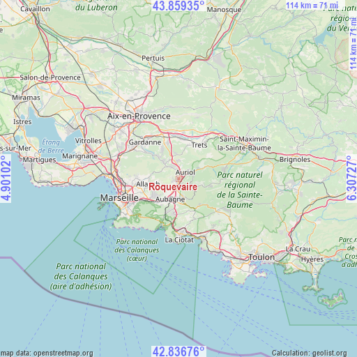
Roquevaire GPS coordinates[2]
43° 21' 0.756" North, 5° 36' 14.904" East
| Map corner | latitude | longitude |
|---|---|---|
| Upper-left | 43.85935°, | 4.90102° |
| Center: | 43.35021°, | 5.60414° |
| Lower-right: | 42.83676°, | 6.30727° |
| Map W x H: | 113.7×113.7 km | = 70.6×70.6mi |
| max Lat: | 51.07786° ⇑94.8% North |
| Roquevaire: | 43.35021° |
| min Lat: | ⇓5.2% South 41.3874° |
| min Long | Roquevaire | max Long |
| -5.08615° | 5.60414° | 9.52242° |
| W 83.7%⇐ | ⇒16.3% E |
Elevation
Elevation of Roquevaire is 160 m = 525 ft, and this is 33.7 m = 111 ft below average elevation for this country.
| Max E: |
2333 m = 7654 ft | 42.4% |
| Avg. | 193.7 m = 635 ft | |
| Roquevaire | 160 m = 525 ft | |
Min E: |
-1 m = -3 ft | 57.6% |
See also: France elevation on elevation.city.
Geographical zone
Roquevaire is located in North temperate zone (between Tropic of Cancer and the Arctic Circle). Distance of this Northern Tropic circle is 2214.2 km =1375.8 mi to South.| Distance of | km | miles | from Roquevaire |
|---|---|---|---|
| North Pole | 5187 | 3223.1 | to North |
| Arctic Circle | 2581.1 | 1603.8 | to North |
| Tropic Cancer | 2214.2 | 1375.8 | to South |
| Equator | 4820.1 | 2995.1 | to South |


Nearby cities:
15 places around Roquevaire: (largest is in red/bold)
• Allauch
10 km =6.2 mi,  260°
260°
• Aubagne
6.9 km =4.3 mi,  202°
202°
• Auriol
3.4 km =2.1 mi,  45°
45°
• Belcodène
8.5 km =5.3 mi,  351°
351°
• Cadolive
7 km =4.3 mi,  317°
317°
• Gémenos
6.2 km =3.9 mi,  161°
161°
• La Bouilladisse
5.2 km =3.2 mi, 350°
• La Destrousse
2.8 km =1.7 mi,  2°
2°
• La Treille
8.6 km =5.3 mi,  242°
242°
• Les Camoins
8.6 km =5.3 mi, 235°
• Peypin
4.4 km =2.7 mi,  331°
331°
• Plan-d'Aups-Sainte-Baume
9.3 km =5.8 mi,  101°
101°
• Saint-Savournin
9 km =5.6 mi, 316°
• Saint-Zacharie
9.3 km =5.8 mi,  65°
65°
• Éoures
8.7 km =5.4 mi,  230°
230°
Sources, notices
• [Note1] Compared only with cities in France existing in our database
• [Src1] Map data: © OpenStreetMap contributors (CC-BY-SA)
• [Src2] Other city data from geonames.org with taken over terms of usage.
• [Src3] Geographical zone / Annual Mean Temperature by Robert A. Rohde @ Wikipedia
