Auriol geodata
Auriol (Provence-Alpes-Côte d'Azur) is a populated place; located in France in Europe/Paris (GMT+2) time zone. With population of 9,872 people, there are 963 cities with bigger population in this country. Compared to other cities in France, 94.6% of cities are located further ↑North; 84% of cities are located further ←West and 72.4% of cities have lower elevation than Auriol. Note1
Administrative division(s):
- Level 1: Provence-Alpes-Côte d'Azur
- Level 2: Département des Bouches-du-Rhône
- Level 3: Arrondissement de Marseille
- Level 4: Auriol


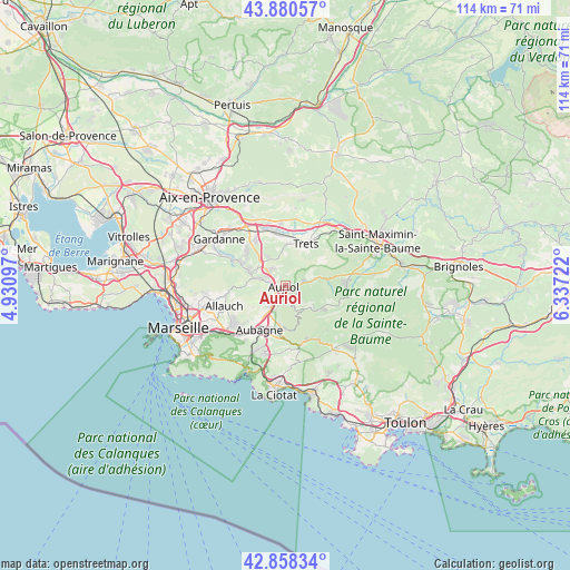
Auriol GPS coordinates[2]
43° 22' 17.796" North, 5° 38' 2.76" East
| Map corner | latitude | longitude |
|---|---|---|
| Upper-left | 43.88057°, | 4.93097° |
| Center: | 43.37161°, | 5.6341° |
| Lower-right: | 42.85834°, | 6.33722° |
| Map W x H: | 113.7×113.7 km | = 70.6×70.6mi |
| max Lat: | 51.07786° ⇑94.6% North |
| Auriol: | 43.37161° |
| min Lat: | ⇓5.4% South 41.3874° |
| min Long | Auriol | max Long |
| -5.08615° | 5.6341° | 9.52242° |
| W 84%⇐ | ⇒16% E |
Elevation
Elevation of Auriol is 232 m = 761 ft, and this is 38.3 m = 126 ft above average elevation for this country.
| Max E: |
2333 m = 7654 ft | 27.6% |
| Auriol | 232 m 761 ft | |
| Avg. | 193.7 m = 635 ft | |
Min E: |
-1 m = -3 ft | 72.4% |
See also: France elevation on elevation.city.
Geographical zone
Auriol is located in North temperate zone (between Tropic of Cancer and the Arctic Circle). Distance of this Northern Tropic circle is 2216.6 km =1377.3 mi to South.| Distance of | km | miles | from Auriol |
|---|---|---|---|
| North Pole | 5184.6 | 3221.6 | to North |
| Arctic Circle | 2578.7 | 1602.3 | to North |
| Tropic Cancer | 2216.6 | 1377.3 | to South |
| Equator | 4822.5 | 2996.6 | to South |


Nearby cities:
15 places around Auriol: (largest is in red/bold)
• Aubagne
10.2 km =6.3 mi,  210°
210°
• Belcodène
7.1 km =4.4 mi,  328°
328°
• Cadolive
7.7 km =4.8 mi,  291°
291°
• Fuveau
11 km =6.8 mi, 327°
• Gréasque
10 km =6.2 mi,  313°
313°
• Gémenos
8.3 km =5.2 mi,  183°
183°
• La Bouilladisse
4.3 km =2.7 mi, 309°
• La Destrousse
2.3 km =1.4 mi,  279°
279°
• Peynier
8.6 km =5.3 mi,  3°
3°
• Peypin
4.8 km =3 mi, 288°
• Plan-d'Aups-Sainte-Baume
7.9 km =4.9 mi,  122°
122°
• Roquevaire
3.4 km =2.1 mi,  225°
225°
• Saint-Savournin
9.6 km =6 mi,  295°
295°
• Saint-Zacharie
6.2 km =3.9 mi,  75°
75°
• Trets
9.4 km =5.8 mi,  25°
25°
Sources, notices
• [Note1] Compared only with cities in France existing in our database
• [Src1] Map data: © OpenStreetMap contributors (CC-BY-SA)
• [Src2] Other city data from geonames.org with taken over terms of usage.
• [Src3] Geographical zone / Annual Mean Temperature by Robert A. Rohde @ Wikipedia
