Beauvais-sur-Matha geodata
Beauvais-sur-Matha (Nouvelle-Aquitaine) is a populated place; located in France in Europe/Paris (GMT+2) time zone. With population of 665 people, there are 12292 cities with bigger population in this country. Compared to other cities in France, 68% of cities are located further ↑North; 79.5% of cities are located further →East and 50.2% of cities have higher elevation than Beauvais-sur-Matha. Note1
Administrative division(s):
- Level 1: Nouvelle-Aquitaine
- Level 2: Charente-Maritime
- Level 3: Arrondissement de Saint-Jean-d'Angély
- Level 4: Beauvais-sur-Matha


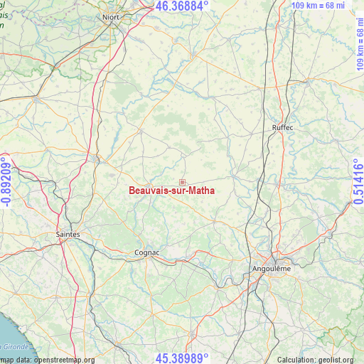
Beauvais-sur-Matha GPS coordinates[2]
45° 52' 53.472" North, 0° 11' 20.256" West
| Map corner | latitude | longitude |
|---|---|---|
| Upper-left | 46.36884°, | -0.89209° |
| Center: | 45.88152°, | -0.18896° |
| Lower-right: | 45.38989°, | 0.51416° |
| Map W x H: | 108.8×108.8 km | = 67.6×67.6mi |
| max Lat: | 51.07786° ⇑68% North |
| Beauvais-sur-Matha: | 45.88152° |
| min Lat: | ⇓32% South 41.3874° |
| min Long | Beauvais-sur-Ma | max Long |
| -5.08615° | -0.18896° | 9.52242° |
| W 20.5%⇐ | ⇒79.5% E |
Elevation
Elevation of Beauvais-sur-Matha is 131 m = 430 ft, and this is 62.7 m = 206 ft below average elevation for this country.
| Max E: |
2333 m = 7654 ft | 50.2% |
| Avg. | 193.7 m = 635 ft | |
| Beauvais-sur-Matha | 131 m = 430 ft | |
Min E: |
-1 m = -3 ft | 49.8% |
See also: France elevation on elevation.city.
Geographical zone
Beauvais-sur-Matha is located in North temperate zone (between Tropic of Cancer and the Arctic Circle). Distance of this North polar circle is 2299.6 km =1428.9 mi to North.| Distance of | km | miles | from Beauvais-sur-Matha |
|---|---|---|---|
| North Pole | 4905.5 | 3048.1 | to North |
| Arctic Circle | 2299.6 | 1428.9 | to North |
| Tropic Cancer | 2495.6 | 1550.7 | to South |
| Equator | 5101.5 | 3169.9 | to South |


Nearby cities:
15 places around Beauvais-sur-Matha: (largest is in red/bold)
• Aigre
15.4 km =9.6 mi,  84°
84°
• Aumagne
16.6 km =10.3 mi,  267°
267°
• Bréville
11 km =6.8 mi,  210°
210°
• Courbillac
12.7 km =7.9 mi,  177°
177°
• Gourville
14.6 km =9.1 mi,  113°
113°
• La Brousse
13.4 km =8.3 mi, 274°
• Les Touches-de-Périgny
6.8 km =4.2 mi,  295°
295°
• Marcillac-Lanville
16.8 km =10.4 mi,  103°
103°
• Matha
10.1 km =6.3 mi,  261°
261°
• Néré
10.9 km =6.8 mi,  340°
340°
• Rouillac
15.2 km =9.4 mi,  140°
140°
• Sainte-Sévère
14.8 km =9.2 mi,  195°
195°
• Sigogne
16.3 km =10.1 mi,  171°
171°
• Sonnac
7.9 km =4.9 mi,  233°
233°
• Villejésus
17 km =10.6 mi, 84°
Sources, notices
• [Note1] Compared only with cities in France existing in our database
• [Src1] Map data: © OpenStreetMap contributors (CC-BY-SA)
• [Src2] Other city data from geonames.org with taken over terms of usage.
• [Src3] Geographical zone / Annual Mean Temperature by Robert A. Rohde @ Wikipedia
