La Brousse geodata
La Brousse (Nouvelle-Aquitaine) is a populated place; located in France in Europe/Paris (GMT+2) time zone. With population of 511 people, there are 15016 cities with bigger population in this country. Compared to other cities in France, 67.8% of cities are located further ↑North; 81.6% of cities are located further →East and 78.6% of cities have higher elevation than La Brousse. Note1
Administrative division(s):
- Level 1: Nouvelle-Aquitaine
- Level 2: Charente-Maritime
- Level 3: Arrondissement de Saint-Jean-d'Angély
- Level 4: La Brousse


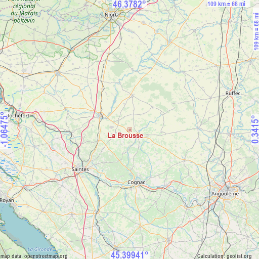
La Brousse GPS coordinates[2]
45° 53' 27.456" North, 0° 21' 41.868" West
| Map corner | latitude | longitude |
|---|---|---|
| Upper-left | 46.3782°, | -1.06475° |
| Center: | 45.89096°, | -0.36163° |
| Lower-right: | 45.39941°, | 0.3415° |
| Map W x H: | 108.8×108.8 km | = 67.6×67.6mi |
| max Lat: | 51.07786° ⇑67.8% North |
| La Brousse: | 45.89096° |
| min Lat: | ⇓32.2% South 41.3874° |
| min Long | La Brousse | max Long |
| -5.08615° | -0.36163° | 9.52242° |
| W 18.4%⇐ | ⇒81.6% E |
Elevation
Elevation of La Brousse is 58 m = 190 ft, and this is 135.7 m = 445 ft below average elevation for this country.
| Max E: |
2333 m = 7654 ft | 78.6% |
| Avg. | 193.7 m = 635 ft | |
| La Brousse | 58 m = 190 ft | |
Min E: |
-1 m = -3 ft | 21.4% |
See also: France elevation on elevation.city.
Geographical zone
La Brousse is located in North temperate zone (between Tropic of Cancer and the Arctic Circle). Distance of this North polar circle is 2298.6 km =1428.3 mi to North.| Distance of | km | miles | from La Brousse |
|---|---|---|---|
| North Pole | 4904.5 | 3047.5 | to North |
| Arctic Circle | 2298.6 | 1428.3 | to North |
| Tropic Cancer | 2496.7 | 1551.4 | to South |
| Equator | 5102.6 | 3170.6 | to South |


Nearby cities:
15 places around La Brousse: (largest is in red/bold)
• Asnières-la-Giraud
12.3 km =7.6 mi,  269°
269°
• Aumagne
3.7 km =2.3 mi,  241°
241°
• Beauvais-sur-Matha
13.4 km =8.3 mi,  94°
94°
• Brizambourg
11.9 km =7.4 mi,  230°
230°
• Bréville
13 km =8.1 mi,  143°
143°
• Burie
14 km =8.7 mi,  199°
199°
• Les Touches-de-Périgny
7.5 km =4.7 mi,  75°
75°
• Matha
4.2 km =2.6 mi,  127°
127°
• Migron
10.2 km =6.3 mi, 195°
• Néré
13.4 km =8.3 mi,  46°
46°
• Saint-Hilaire-de-Villefranche
13.8 km =8.6 mi,  251°
251°
• Saint-Jean-d’Angély
13.7 km =8.5 mi,  295°
295°
• Sonnac
9.1 km =5.7 mi, 129°
• Varaize
6 km =3.7 mi,  306°
306°
• Écoyeux
13.5 km =8.4 mi, 235°
Sources, notices
• [Note1] Compared only with cities in France existing in our database
• [Src1] Map data: © OpenStreetMap contributors (CC-BY-SA)
• [Src2] Other city data from geonames.org with taken over terms of usage.
• [Src3] Geographical zone / Annual Mean Temperature by Robert A. Rohde @ Wikipedia
