Aumagne geodata
Aumagne (Nouvelle-Aquitaine) is a populated place; located in France in Europe/Paris (GMT+2) time zone. With population of 655 people, there are 12455 cities with bigger population in this country. Compared to other cities in France, 68.1% of cities are located further ↑North; 82.2% of cities are located further →East and 87.4% of cities have higher elevation than Aumagne. Note1
Administrative division(s):
- Level 1: Nouvelle-Aquitaine
- Level 2: Charente-Maritime
- Level 3: Arrondissement de Saint-Jean-d'Angély
- Level 4: Aumagne


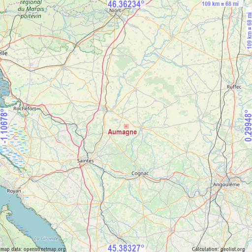
Aumagne GPS coordinates[2]
45° 52' 29.856" North, 0° 24' 13.14" West
| Map corner | latitude | longitude |
|---|---|---|
| Upper-left | 46.36234°, | -1.10678° |
| Center: | 45.87496°, | -0.40365° |
| Lower-right: | 45.38327°, | 0.29948° |
| Map W x H: | 108.9×108.9 km | = 67.7×67.7mi |
| max Lat: | 51.07786° ⇑68.1% North |
| Aumagne: | 45.87496° |
| min Lat: | ⇓31.9% South 41.3874° |
| min Long | Aumagne | max Long |
| -5.08615° | -0.40365° | 9.52242° |
| W 17.8%⇐ | ⇒82.2% E |
Elevation
Elevation of Aumagne is 36 m = 118 ft, and this is 157.7 m = 517 ft below average elevation for this country.
| Max E: |
2333 m = 7654 ft | 87.4% |
| Avg. | 193.7 m = 635 ft | |
| Aumagne | 36 m = 118 ft | |
Min E: |
-1 m = -3 ft | 12.6% |
See also: France elevation on elevation.city.
Geographical zone
Aumagne is located in North temperate zone (between Tropic of Cancer and the Arctic Circle). Distance of this North polar circle is 2300.4 km =1429.4 mi to North.| Distance of | km | miles | from Aumagne |
|---|---|---|---|
| North Pole | 4906.2 | 3048.6 | to North |
| Arctic Circle | 2300.4 | 1429.4 | to North |
| Tropic Cancer | 2494.9 | 1550.3 | to South |
| Equator | 5100.8 | 3169.5 | to South |


Nearby cities:
15 places around Aumagne: (largest is in red/bold)
• Asnières-la-Giraud
9.2 km =5.7 mi,  280°
280°
• Brizambourg
8.3 km =5.2 mi,  225°
225°
• Burie
11.5 km =7.1 mi,  187°
187°
• La Brousse
3.7 km =2.3 mi,  61°
61°
• Le Douhet
13.9 km =8.6 mi,  245°
245°
• Les Touches-de-Périgny
11.1 km =6.9 mi,  71°
71°
• Matha
6.6 km =4.1 mi,  96°
96°
• Mazeray
12.9 km =8 mi,  286°
286°
• Migron
8.1 km =5 mi,  175°
175°
• Saint-Hilaire-de-Villefranche
10.1 km =6.3 mi, 254°
• Saint-Jean-d’Angély
11.9 km =7.4 mi,  310°
310°
• Saint-Sulpice-de-Cognac
12.9 km =8 mi,  172°
172°
• Sonnac
11 km =6.8 mi,  111°
111°
• Varaize
5.6 km =3.5 mi,  343°
343°
• Écoyeux
9.8 km =6.1 mi, 233°
Sources, notices
• [Note1] Compared only with cities in France existing in our database
• [Src1] Map data: © OpenStreetMap contributors (CC-BY-SA)
• [Src2] Other city data from geonames.org with taken over terms of usage.
• [Src3] Geographical zone / Annual Mean Temperature by Robert A. Rohde @ Wikipedia
