Les Touches-de-Périgny geodata
Les Touches-de-Périgny (Nouvelle-Aquitaine) is a populated place; located in France in Europe/Paris (GMT+2) time zone. With population of 533 people, there are 14546 cities with bigger population in this country. Compared to other cities in France, 67.5% of cities are located further ↑North; 80.5% of cities are located further →East and 79.4% of cities have higher elevation than Les Touches-de-Périgny. Note1
Administrative division(s):
- Level 1: Nouvelle-Aquitaine
- Level 2: Charente-Maritime
- Level 3: Arrondissement de Saint-Jean-d'Angély
- Level 4: Les Touches-de-Périgny
Current local time in Les Touches-de-Périgny:
03:22 PM, SaturdayDifference from your time zone: hours


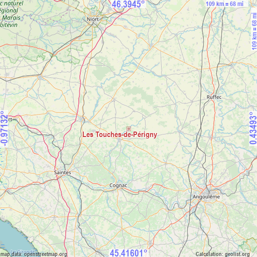
Les Touches-de-Périgny GPS coordinates[2]
45° 54' 26.676" North, 0° 16' 5.484" West
| Map corner | latitude | longitude |
|---|---|---|
| Upper-left | 46.3945°, | -0.97132° |
| Center: | 45.90741°, | -0.26819° |
| Lower-right: | 45.41601°, | 0.43493° |
| Map W x H: | 108.8×108.8 km | = 67.6×67.6mi |
| max Lat: | 51.07786° ⇑67.5% North |
| Les Touches-de-Périgny: | 45.90741° |
| min Lat: | ⇓32.5% South 41.3874° |
| min Long | Les Touches-de- | max Long |
| -5.08615° | -0.26819° | 9.52242° |
| W 19.5%⇐ | ⇒80.5% E |
Elevation
Elevation of Les Touches-de-Périgny is 56 m = 184 ft, and this is 137.7 m = 452 ft below average elevation for this country.
| Max E: |
2333 m = 7654 ft | 79.4% |
| Avg. | 193.7 m = 635 ft | |
| Les Touches-de-Périgny | 56 m = 184 ft | |
Min E: |
-1 m = -3 ft | 20.6% |
See also: France elevation on elevation.city.
Geographical zone
Les Touches-de-Périgny is located in North temperate zone (between Tropic of Cancer and the Arctic Circle). Distance of this North polar circle is 2296.7 km =1427.1 mi to North.| Distance of | km | miles | from Les Touches-de-Périgny |
|---|---|---|---|
| North Pole | 4902.6 | 3046.3 | to North |
| Arctic Circle | 2296.7 | 1427.1 | to North |
| Tropic Cancer | 2498.5 | 1552.5 | to South |
| Equator | 5104.4 | 3171.7 | to South |


Nearby cities:
15 places around Les Touches-de-Périgny: (largest is in red/bold)
• Aulnay
14 km =8.7 mi,  333°
333°
• Aumagne
11.1 km =6.9 mi,  251°
251°
• Beauvais-sur-Matha
6.8 km =4.2 mi,  115°
115°
• Brizambourg
19 km =11.8 mi,  240°
240°
• Bréville
12.3 km =7.6 mi,  177°
177°
• Burie
19.2 km =11.9 mi,  218°
218°
• Courbillac
17 km =10.6 mi,  156°
156°
• La Brousse
7.5 km =4.7 mi,  255°
255°
• Matha
5.8 km =3.6 mi, 221°
• Migron
15.3 km =9.5 mi, 220°
• Néré
7.8 km =4.8 mi,  18°
18°
• Saint-Sulpice-de-Cognac
18.6 km =11.6 mi,  208°
208°
• Sainte-Sévère
17.4 km =10.8 mi,  172°
172°
• Sonnac
7.6 km =4.7 mi, 181°
• Varaize
12.2 km =7.6 mi,  278°
278°
Sources, notices
• [Note1] Compared only with cities in France existing in our database
• [Src1] Map data: © OpenStreetMap contributors (CC-BY-SA)
• [Src2] Other city data from geonames.org with taken over terms of usage.
• [Src3] Geographical zone / Annual Mean Temperature by Robert A. Rohde @ Wikipedia
