Bazoches-sur-Hoëne geodata
Bazoches-sur-Hoëne (Normandy) is a populated place; located in France in Europe/Paris (GMT+2) time zone. With population of 931 people, there are 9375 cities with bigger population in this country. Compared to other cities in France, 69.6% of cities are located further ↓South; 73.6% of cities are located further →East and 63.8% of cities have lower elevation than Bazoches-sur-Hoëne. Note1
Administrative division(s):
- Level 1: Normandy
- Level 2: Département de l'Orne
- Level 3: Arrondissement de Mortagne-au-Perche
- Level 4: Bazoches-sur-Hoëne


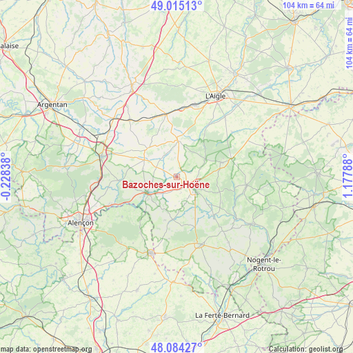
Bazoches-sur-Hoëne GPS coordinates[2]
48° 33' 6.624" North, 0° 28' 29.1" East
| Map corner | latitude | longitude |
|---|---|---|
| Upper-left | 49.01513°, | -0.22838° |
| Center: | 48.55184°, | 0.47475° |
| Lower-right: | 48.08427°, | 1.17788° |
| Map W x H: | 103.5×103.5 km | = 64.3×64.3mi |
| max Lat: | 51.07786° ⇑30.4% North |
| Bazoches-sur-Hoëne: | 48.55184° |
| min Lat: | ⇓69.6% South 41.3874° |
| min Long | Bazoches-sur-Ho | max Long |
| -5.08615° | 0.47475° | 9.52242° |
| W 26.4%⇐ | ⇒73.6% E |
Elevation
Elevation of Bazoches-sur-Hoëne is 188 m = 617 ft, and this is 5.7 m = 19 ft below average elevation for this country.
| Max E: |
2333 m = 7654 ft | 36.2% |
| Avg. | 193.7 m = 635 ft | |
| Bazoches-sur-Hoëne | 188 m = 617 ft | |
Min E: |
-1 m = -3 ft | 63.8% |
See also: France elevation on elevation.city.
Geographical zone
Bazoches-sur-Hoëne is located in North temperate zone (between Tropic of Cancer and the Arctic Circle). Distance of this North polar circle is 2002.7 km =1244.4 mi to North.| Distance of | km | miles | from Bazoches-sur-Hoëne |
|---|---|---|---|
| North Pole | 4608.6 | 2863.7 | to North |
| Arctic Circle | 2002.7 | 1244.4 | to North |
| Tropic Cancer | 2792.5 | 1735.2 | to South |
| Equator | 5398.5 | 3354.5 | to South |


Nearby cities:
15 places around Bazoches-sur-Hoëne: (largest is in red/bold)
• Courtomer
12.1 km =7.5 mi,  314°
314°
• Essay
16.8 km =10.4 mi,  266°
266°
• La Chapelle-Montligeon
15.4 km =9.6 mi,  120°
120°
• Le Mêle-sur-Sarthe
9.8 km =6.1 mi,  243°
243°
• Le Pin-la-Garenne
13.2 km =8.2 mi,  156°
156°
• Mauves-sur-Huisne
15.6 km =9.7 mi,  136°
136°
• Mortagne-au-Perche
6.4 km =4 mi, 123°
• Moulins-la-Marche
11 km =6.8 mi,  0°
0°
• Randonnai
18.3 km =11.4 mi,  53°
53°
• Saint-Hilaire-le-Châtel
4.1 km =2.5 mi,  72°
72°
• Saint-Julien-sur-Sarthe
10.9 km =6.8 mi,  231°
231°
• Saint-Langis-lès-Mortagne
6.9 km =4.3 mi,  126°
126°
• Sainte-Scolasse-sur-Sarthe
6.6 km =4.1 mi,  294°
294°
• Soligny-la-Trappe
8.3 km =5.2 mi,  32°
32°
• Tourouvre
13.7 km =8.5 mi, 72°
Sources, notices
• [Note1] Compared only with cities in France existing in our database
• [Src1] Map data: © OpenStreetMap contributors (CC-BY-SA)
• [Src2] Other city data from geonames.org with taken over terms of usage.
• [Src3] Geographical zone / Annual Mean Temperature by Robert A. Rohde @ Wikipedia
