La Chapelle-Montligeon geodata
La Chapelle-Montligeon (Normandy) is a populated place; located in France in Europe/Paris (GMT+2) time zone. With population of 727 people, there are 11442 cities with bigger population in this country. Compared to other cities in France, 67.9% of cities are located further ↓South; 71.8% of cities are located further →East and 59.6% of cities have lower elevation than La Chapelle-Montligeon. Note1
Administrative division(s):
- Level 1: Normandy
- Level 2: Département de l'Orne
- Level 3: Arrondissement de Mortagne-au-Perche
- Level 4: La Chapelle-Montligeon
Current local time in La Chapelle-Montligeon:
11:25 AM, SaturdayDifference from your time zone: hours


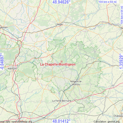
La Chapelle-Montligeon GPS coordinates[2]
48° 28' 56.388" North, 0° 39' 22.176" East
| Map corner | latitude | longitude |
|---|---|---|
| Upper-left | 48.94626°, | -0.04697° |
| Center: | 48.48233°, | 0.65616° |
| Lower-right: | 48.01412°, | 1.35929° |
| Map W x H: | 103.6×103.6 km | = 64.4×64.4mi |
| max Lat: | 51.07786° ⇑32.1% North |
| La Chapelle-Montligeon: | 48.48233° |
| min Lat: | ⇓67.9% South 41.3874° |
| min Long | La Chapelle-Mon | max Long |
| -5.08615° | 0.65616° | 9.52242° |
| W 28.2%⇐ | ⇒71.8% E |
Elevation
Elevation of La Chapelle-Montligeon is 168 m = 551 ft, and this is 25.7 m = 84 ft below average elevation for this country.
| Max E: |
2333 m = 7654 ft | 40.4% |
| Avg. | 193.7 m = 635 ft | |
| La Chapelle-Montligeon | 168 m = 551 ft | |
Min E: |
-1 m = -3 ft | 59.6% |
See also: France elevation on elevation.city.
Geographical zone
La Chapelle-Montligeon is located in North temperate zone (between Tropic of Cancer and the Arctic Circle). Distance of this North polar circle is 2010.4 km =1249.2 mi to North.| Distance of | km | miles | from La Chapelle-Montligeon |
|---|---|---|---|
| North Pole | 4616.3 | 2868.4 | to North |
| Arctic Circle | 2010.4 | 1249.2 | to North |
| Tropic Cancer | 2784.8 | 1730.4 | to South |
| Equator | 5390.7 | 3349.6 | to South |


Nearby cities:
15 places around La Chapelle-Montligeon: (largest is in red/bold)
• Bazoches-sur-Hoëne
15.4 km =9.6 mi,  300°
300°
• Bellême
13.7 km =8.5 mi,  207°
207°
• Le Gué-de-la-Chaîne
15.7 km =9.8 mi,  219°
219°
• Le Pin-la-Garenne
9.1 km =5.7 mi,  241°
241°
• Longny-au-Perche
8.8 km =5.5 mi,  53°
53°
• Mauves-sur-Huisne
4.4 km =2.7 mi, 216°
• Mortagne-au-Perche
9.1 km =5.7 mi, 297°
• Moutiers-au-Perche
14 km =8.7 mi,  92°
92°
• Nocé
11.6 km =7.2 mi,  170°
170°
• Rémalard
10.4 km =6.5 mi,  124°
124°
• Saint-Hilaire-le-Châtel
13 km =8.1 mi,  313°
313°
• Saint-Langis-lès-Mortagne
8.7 km =5.4 mi, 295°
• Saint-Martin-du-Vieux-Bellême
14 km =8.7 mi, 216°
• Soligny-la-Trappe
17.1 km =10.6 mi,  328°
328°
• Tourouvre
11.9 km =7.4 mi,  358°
358°
Sources, notices
• [Note1] Compared only with cities in France existing in our database
• [Src1] Map data: © OpenStreetMap contributors (CC-BY-SA)
• [Src2] Other city data from geonames.org with taken over terms of usage.
• [Src3] Geographical zone / Annual Mean Temperature by Robert A. Rohde @ Wikipedia
