Baudoncourt geodata
Baudoncourt (Bourgogne-Franche-Comté) is a populated place; located in France in Europe/Paris (GMT+2) time zone. With population of 534 people, there are 14532 cities with bigger population in this country. Compared to other cities in France, 55.4% of cities are located further ↓South; 90.7% of cities are located further ←West and 76.7% of cities have lower elevation than Baudoncourt. Note1
Administrative division(s):
- Level 1: Bourgogne-Franche-Comté
- Level 2: Département de la Haute-Saône
- Level 3: Arrondissement de Lure
- Level 4: Baudoncourt


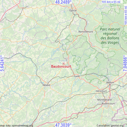
Baudoncourt GPS coordinates[2]
47° 46' 42.78" North, 6° 20' 43.908" East
| Map corner | latitude | longitude |
|---|---|---|
| Upper-left | 48.2489°, | 5.64241° |
| Center: | 47.77855°, | 6.34553° |
| Lower-right: | 47.3039°, | 7.04866° |
| Map W x H: | 105.1×105.1 km | = 65.3×65.3mi |
| max Lat: | 51.07786° ⇑44.6% North |
| Baudoncourt: | 47.77855° |
| min Lat: | ⇓55.4% South 41.3874° |
| min Long | Baudoncourt | max Long |
| -5.08615° | 6.34553° | 9.52242° |
| W 90.7%⇐ | ⇒9.3% E |
Elevation
Elevation of Baudoncourt is 261 m = 856 ft, and this is 67.3 m = 221 ft above average elevation for this country.
| Max E: |
2333 m = 7654 ft | 23.3% |
| Baudoncourt | 261 m 856 ft | |
| Avg. | 193.7 m = 635 ft | |
Min E: |
-1 m = -3 ft | 76.7% |
See also: France elevation on elevation.city.
Geographical zone
Baudoncourt is located in North temperate zone (between Tropic of Cancer and the Arctic Circle). Distance of this North polar circle is 2088.7 km =1297.9 mi to North.| Distance of | km | miles | from Baudoncourt |
|---|---|---|---|
| North Pole | 4694.6 | 2917.1 | to North |
| Arctic Circle | 2088.7 | 1297.9 | to North |
| Tropic Cancer | 2706.6 | 1681.8 | to South |
| Equator | 5312.5 | 3301 | to South |


Nearby cities:
15 places around Baudoncourt: (largest is in red/bold)
• Breuches
2.6 km =1.6 mi,  331°
331°
• Citers
6.3 km =3.9 mi,  130°
130°
• Conflans-sur-Lanterne
10.5 km =6.5 mi,  293°
293°
• Corbenay
12.7 km =7.9 mi,  354°
354°
• Fontaine-lès-Luxeuil
8.6 km =5.3 mi, 354°
• Fougerolles
12.7 km =7.9 mi,  20°
20°
• Froideconche
7 km =4.3 mi,  47°
47°
• Lure
15.5 km =9.6 mi, 133°
• Luxeuil-les-Bains
4.5 km =2.8 mi, 18°
• Magny-Vernois
15.5 km =9.6 mi,  141°
141°
• Raddon-et-Chapendu
12.1 km =7.5 mi, 52°
• Saint-Germain
15.1 km =9.4 mi,  113°
113°
• Saint-Loup-sur-Semouse
12.8 km =8 mi,  335°
335°
• Saint-Sauveur
4.2 km =2.6 mi, 45°
• Saulx
9.9 km =6.2 mi,  208°
208°
Sources, notices
• [Note1] Compared only with cities in France existing in our database
• [Src1] Map data: © OpenStreetMap contributors (CC-BY-SA)
• [Src2] Other city data from geonames.org with taken over terms of usage.
• [Src3] Geographical zone / Annual Mean Temperature by Robert A. Rohde @ Wikipedia
