Fontaine-lès-Luxeuil geodata
Fontaine-lès-Luxeuil (Bourgogne-Franche-Comté) is a populated place; located in France in Europe/Paris (GMT+2) time zone. With population of 1,477 people, there are 6265 cities with bigger population in this country. Compared to other cities in France, 56.7% of cities are located further ↓South; 90.6% of cities are located further ←West and 77.1% of cities have lower elevation than Fontaine-lès-Luxeuil. Note1
Administrative division(s):
- Level 1: Bourgogne-Franche-Comté
- Level 2: Département de la Haute-Saône
- Level 3: Arrondissement de Lure
- Level 4: Fontaine-lès-Luxeuil


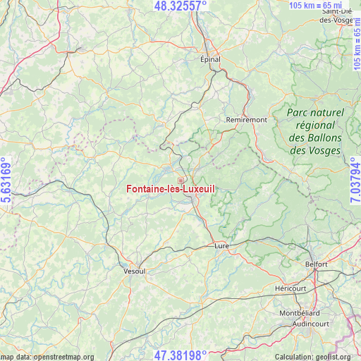
Fontaine-lès-Luxeuil GPS coordinates[2]
47° 51' 21.312" North, 6° 20' 5.352" East
| Map corner | latitude | longitude |
|---|---|---|
| Upper-left | 48.32557°, | 5.63169° |
| Center: | 47.85592°, | 6.33482° |
| Lower-right: | 47.38198°, | 7.03794° |
| Map W x H: | 104.9×104.9 km | = 65.2×65.2mi |
| max Lat: | 51.07786° ⇑43.3% North |
| Fontaine-lès-Luxeuil: | 47.85592° |
| min Lat: | ⇓56.7% South 41.3874° |
| min Long | Fontaine-lès-L | max Long |
| -5.08615° | 6.33482° | 9.52242° |
| W 90.6%⇐ | ⇒9.4% E |
Elevation
Elevation of Fontaine-lès-Luxeuil is 264 m = 866 ft, and this is 70.3 m = 231 ft above average elevation for this country.
| Max E: |
2333 m = 7654 ft | 22.9% |
| Fontaine-lès-Luxeuil | 264 m 866 ft | |
| Avg. | 193.7 m = 635 ft | |
Min E: |
-1 m = -3 ft | 77.1% |
See also: France elevation on elevation.city.
Geographical zone
Fontaine-lès-Luxeuil is located in North temperate zone (between Tropic of Cancer and the Arctic Circle). Distance of this North polar circle is 2080.1 km =1292.5 mi to North.| Distance of | km | miles | from Fontaine-lès-Luxeuil |
|---|---|---|---|
| North Pole | 4686 | 2911.7 | to North |
| Arctic Circle | 2080.1 | 1292.5 | to North |
| Tropic Cancer | 2715.2 | 1687.1 | to South |
| Equator | 5321.1 | 3306.4 | to South |


Nearby cities:
15 places around Fontaine-lès-Luxeuil: (largest is in red/bold)
• Aillevillers-et-Lyaumont
7.2 km =4.5 mi,  1°
1°
• Baudoncourt
8.6 km =5.3 mi,  174°
174°
• Breuches
6.3 km =3.9 mi,  184°
184°
• Citers
13.8 km =8.6 mi,  156°
156°
• Conflans-sur-Lanterne
9.8 km =6.1 mi,  243°
243°
• Corbenay
4.1 km =2.5 mi,  355°
355°
• Fontenoy-le-Château
16.5 km =10.3 mi,  322°
322°
• Fougerolles
6.1 km =3.8 mi,  57°
57°
• Froideconche
7.1 km =4.4 mi,  122°
122°
• Le Clerjus
11.8 km =7.3 mi, 356°
• Luxeuil-les-Bains
4.9 km =3 mi,  152°
152°
• Plombières-les-Bains
15 km =9.3 mi,  37°
37°
• Raddon-et-Chapendu
10.5 km =6.5 mi,  96°
96°
• Saint-Loup-sur-Semouse
5.4 km =3.4 mi,  304°
304°
• Saint-Sauveur
6.8 km =4.2 mi, 145°
Sources, notices
• [Note1] Compared only with cities in France existing in our database
• [Src1] Map data: © OpenStreetMap contributors (CC-BY-SA)
• [Src2] Other city data from geonames.org with taken over terms of usage.
• [Src3] Geographical zone / Annual Mean Temperature by Robert A. Rohde @ Wikipedia
