Rezé geodata
Rezé (Pays de la Loire) is a populated place; located in France in Europe/Paris (GMT+2) time zone. With population of 39,248 people, there are 187 cities with bigger population in this country. Compared to other cities in France, 53.3% of cities are located further ↑North; 92.6% of cities are located further →East and 90.7% of cities have higher elevation than Rezé. Note1
Administrative division(s):
- Level 1: Pays de la Loire
- Level 2: Loire-Atlantique
- Level 3: Arrondissement de Nantes
- Level 4: Rezé


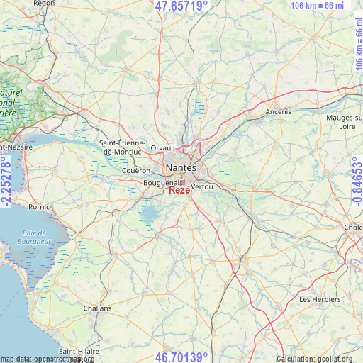
Rezé GPS coordinates[2]
47° 10' 53.184" North, 1° 32' 58.74" West
| Map corner | latitude | longitude |
|---|---|---|
| Upper-left | 47.65719°, | -2.25278° |
| Center: | 47.18144°, | -1.54965° |
| Lower-right: | 46.70139°, | -0.84653° |
| Map W x H: | 106.3×106.3 km | = 66.1×66.1mi |
| max Lat: | 51.07786° ⇑53.3% North |
| Rezé: | 47.18144° |
| min Lat: | ⇓46.7% South 41.3874° |
| min Long | Rezé | max Long |
| -5.08615° | -1.54965° | 9.52242° |
| W 7.4%⇐ | ⇒92.6% E |
Elevation
Elevation of Rezé is 28 m = 92 ft, and this is 165.7 m = 544 ft below average elevation for this country.
| Max E: |
2333 m = 7654 ft | 90.7% |
| Avg. | 193.7 m = 635 ft | |
| Rezé | 28 m = 92 ft | |
Min E: |
-1 m = -3 ft | 9.3% |
See also: France elevation on elevation.city.
Geographical zone
Rezé is located in North temperate zone (between Tropic of Cancer and the Arctic Circle). Distance of this North polar circle is 2155.1 km =1339.1 mi to North.| Distance of | km | miles | from Rezé |
|---|---|---|---|
| North Pole | 4761 | 2958.3 | to North |
| Arctic Circle | 2155.1 | 1339.1 | to North |
| Tropic Cancer | 2640.2 | 1640.5 | to South |
| Equator | 5246.1 | 3259.8 | to South |


Nearby cities:
15 places around Rezé: (largest is in red/bold)
• Basse-Goulaine
7.1 km =4.4 mi,  61°
61°
• Bouguenais
5.4 km =3.4 mi,  265°
265°
• Haute-Goulaine
9.3 km =5.8 mi,  77°
77°
• Indre
9.1 km =5.7 mi,  283°
283°
• La Chevrolière
11 km =6.8 mi,  204°
204°
• La Montagne
10.1 km =6.3 mi, 273°
• Le Bignon
10.3 km =6.4 mi,  154°
154°
• Les Sorinières
4 km =2.5 mi,  157°
157°
• Nantes
4 km =2.5 mi,  355°
355°
• Pont-Saint-Martin
7 km =4.3 mi, 202°
• Saint-Fiacre-sur-Maine
10.9 km =6.8 mi,  113°
113°
• Saint-Herblain
8.5 km =5.3 mi,  298°
298°
• Saint-Sébastien-sur-Loire
4.6 km =2.9 mi,  50°
50°
• Sainte-Luce-sur-Loire
9.4 km =5.8 mi,  31°
31°
• Vertou
6.2 km =3.9 mi,  103°
103°
Sources, notices
• [Note1] Compared only with cities in France existing in our database
• [Src1] Map data: © OpenStreetMap contributors (CC-BY-SA)
• [Src2] Other city data from geonames.org with taken over terms of usage.
• [Src3] Geographical zone / Annual Mean Temperature by Robert A. Rohde @ Wikipedia
