Pujaut geodata
Pujaut (Occitanie) is a populated place; located in France in Europe/Paris (GMT+2) time zone. With population of 3,828 people, there are 2573 cities with bigger population in this country. Compared to other cities in France, 87.1% of cities are located further ↑North; 74.7% of cities are located further ←West and 75% of cities have higher elevation than Pujaut. Note1
Administrative division(s):
- Level 1: Occitanie
- Level 2: Gard
- Level 3: Arrondissement de Nîmes
- Level 4: Pujaut


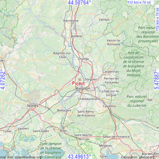
Pujaut GPS coordinates[2]
44° 0' 14.544" North, 4° 46' 32.7" East
| Map corner | latitude | longitude |
|---|---|---|
| Upper-left | 44.50764°, | 4.07262° |
| Center: | 44.00404°, | 4.77575° |
| Lower-right: | 43.49613°, | 5.47887° |
| Map W x H: | 112.5×112.5 km | = 69.9×69.9mi |
| max Lat: | 51.07786° ⇑87.1% North |
| Pujaut: | 44.00404° |
| min Lat: | ⇓12.9% South 41.3874° |
| min Long | Pujaut | max Long |
| -5.08615° | 4.77575° | 9.52242° |
| W 74.7%⇐ | ⇒25.3% E |
Elevation
Elevation of Pujaut is 67 m = 220 ft, and this is 126.7 m = 416 ft below average elevation for this country.
| Max E: |
2333 m = 7654 ft | 75% |
| Avg. | 193.7 m = 635 ft | |
| Pujaut | 67 m = 220 ft | |
Min E: |
-1 m = -3 ft | 25% |
See also: France elevation on elevation.city.
Geographical zone
Pujaut is located in North temperate zone (between Tropic of Cancer and the Arctic Circle). Distance of this Northern Tropic circle is 2286.9 km =1421 mi to South.| Distance of | km | miles | from Pujaut |
|---|---|---|---|
| North Pole | 5114.3 | 3177.9 | to North |
| Arctic Circle | 2508.4 | 1558.6 | to North |
| Tropic Cancer | 2286.9 | 1421 | to South |
| Equator | 4892.8 | 3040.2 | to South |


Nearby cities:
15 places around Pujaut: (largest is in red/bold)
• Avignon
6.7 km =4.2 mi,  156°
156°
• Châteauneuf-du-Pape
7.4 km =4.6 mi,  37°
37°
• Le Pontet
8.3 km =5.2 mi,  125°
125°
• Les Angles
5.2 km =3.2 mi,  190°
190°
• Lirac
7.9 km =4.9 mi,  296°
296°
• Montfaucon
7.8 km =4.8 mi,  347°
347°
• Rochefort-du-Gard
7.5 km =4.7 mi,  245°
245°
• Roquemaure
5 km =3.1 mi,  1°
1°
• Saint-Geniès-de-Comolas
8.2 km =5.1 mi,  327°
327°
• Saint-Laurent-des-Arbres
8.3 km =5.2 mi,  313°
313°
• Sauveterre
2.5 km =1.6 mi,  34°
34°
• Saze
10.1 km =6.3 mi,  228°
228°
• Sorgues
7.9 km =4.9 mi,  84°
84°
• Tavel
6.3 km =3.9 mi,  278°
278°
• Villeneuve-lès-Avignon
4.3 km =2.7 mi, 157°
Sources, notices
• [Note1] Compared only with cities in France existing in our database
• [Src1] Map data: © OpenStreetMap contributors (CC-BY-SA)
• [Src2] Other city data from geonames.org with taken over terms of usage.
• [Src3] Geographical zone / Annual Mean Temperature by Robert A. Rohde @ Wikipedia
