Plan-d'Aups-Sainte-Baume geodata
Plan-d'Aups-Sainte-Baume (Provence-Alpes-Côte d'Azur) is a populated place; located in France in Europe/Paris (GMT+2) time zone. With population of 1,176 people, there are 7669 cities with bigger population in this country. Compared to other cities in France, 95.1% of cities are located further ↑North; 84.5% of cities are located further ←West and 96.3% of cities have lower elevation than Plan-d'Aups-Sainte-Baume. Note1
Administrative division(s):
- Level 1: Provence-Alpes-Côte d'Azur
- Level 2: Var
- Level 3: Arrondissement de Brignoles
- Level 4: Plan-d'Aups-Sainte-Baume
Current local time in Plan-d'Aups-Sainte-Baume:
02:06 AM, MondayDifference from your time zone: hours


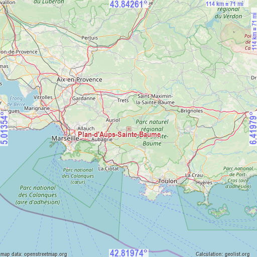
Plan-d'Aups-Sainte-Baume GPS coordinates[2]
43° 19' 59.988" North, 5° 43' 0.012" East
| Map corner | latitude | longitude |
|---|---|---|
| Upper-left | 43.84261°, | 5.01354° |
| Center: | 43.33333°, | 5.71667° |
| Lower-right: | 42.81974°, | 6.41979° |
| Map W x H: | 113.7×113.7 km | = 70.6×70.6mi |
| max Lat: | 51.07786° ⇑95.1% North |
| Plan-d'Aups-Sainte-Baume: | 43.33333° |
| min Lat: | ⇓4.9% South 41.3874° |
| min Long | Plan-d'Aups-Sai | max Long |
| -5.08615° | 5.71667° | 9.52242° |
| W 84.5%⇐ | ⇒15.5% E |
Elevation
Elevation of Plan-d'Aups-Sainte-Baume is 669 m = 2195 ft, and this is 475.3 m = 1559 ft above average elevation for this country.
| Max E: |
2333 m = 7654 ft | 3.7% |
| Plan-d'Aups-Sainte-Baume | 669 m 2195 ft | |
| Avg. | 193.7 m = 635 ft | |
Min E: |
-1 m = -3 ft | 96.3% |
See also: France elevation on elevation.city.
Geographical zone
Plan-d'Aups-Sainte-Baume is located in North temperate zone (between Tropic of Cancer and the Arctic Circle). Distance of this Northern Tropic circle is 2212.3 km =1374.7 mi to South.| Distance of | km | miles | from Plan-d'Aups-Sainte-Baume |
|---|---|---|---|
| North Pole | 5188.8 | 3224.2 | to North |
| Arctic Circle | 2583 | 1605 | to North |
| Tropic Cancer | 2212.3 | 1374.7 | to South |
| Equator | 4818.2 | 2993.9 | to South |


Nearby cities:
15 places around Plan-d'Aups-Sainte-Baume: (largest is in red/bold)
• Aubagne
12.6 km =7.8 mi,  249°
249°
• Auriol
7.9 km =4.9 mi,  302°
302°
• Cuges-les-Pins
6.5 km =4 mi,  192°
192°
• Gémenos
8.2 km =5.1 mi,  240°
240°
• La Bouilladisse
12.2 km =7.6 mi, 304°
• La Destrousse
10.1 km =6.3 mi, 297°
• Nans-les-Pins
6.7 km =4.2 mi,  51°
51°
• Peynier
14.2 km =8.8 mi,  334°
334°
• Peypin
12.6 km =7.8 mi, 297°
• Roquefort-la-Bédoule
13.9 km =8.6 mi,  227°
227°
• Roquevaire
9.3 km =5.8 mi,  281°
281°
• Rougiers
12.7 km =7.9 mi,  58°
58°
• Saint-Zacharie
5.8 km =3.6 mi,  353°
353°
• Signes
12.7 km =7.9 mi,  111°
111°
• Trets
13.1 km =8.1 mi, 348°
Sources, notices
• [Note1] Compared only with cities in France existing in our database
• [Src1] Map data: © OpenStreetMap contributors (CC-BY-SA)
• [Src2] Other city data from geonames.org with taken over terms of usage.
• [Src3] Geographical zone / Annual Mean Temperature by Robert A. Rohde @ Wikipedia
