Amailloux geodata
Amailloux (Nouvelle-Aquitaine) is a populated place; located in France in Europe/Paris (GMT+2) time zone. With population of 744 people, there are 11239 cities with bigger population in this country. Compared to other cities in France, 57.7% of cities are located further ↑North; 81% of cities are located further →East and 58.3% of cities have lower elevation than Amailloux. Note1
Administrative division(s):
- Level 1: Nouvelle-Aquitaine
- Level 2: Département des Deux-Sèvres
- Level 3: Arrondissement de Parthenay
- Level 4: Amailloux


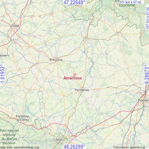
Amailloux GPS coordinates[2]
46° 44' 48.624" North, 0° 18' 59.004" West
| Map corner | latitude | longitude |
|---|---|---|
| Upper-left | 47.22649°, | -1.01952° |
| Center: | 46.74684°, | -0.31639° |
| Lower-right: | 46.26289°, | 0.38673° |
| Map W x H: | 107.1×107.1 km | = 66.5×66.5mi |
| max Lat: | 51.07786° ⇑57.7% North |
| Amailloux: | 46.74684° |
| min Lat: | ⇓42.3% South 41.3874° |
| min Long | Amailloux | max Long |
| -5.08615° | -0.31639° | 9.52242° |
| W 19%⇐ | ⇒81% E |
Elevation
Elevation of Amailloux is 162 m = 531 ft, and this is 31.7 m = 104 ft below average elevation for this country.
| Max E: |
2333 m = 7654 ft | 41.7% |
| Avg. | 193.7 m = 635 ft | |
| Amailloux | 162 m = 531 ft | |
Min E: |
-1 m = -3 ft | 58.3% |
See also: France elevation on elevation.city.
Geographical zone
Amailloux is located in North temperate zone (between Tropic of Cancer and the Arctic Circle). Distance of this North polar circle is 2203.4 km =1369.1 mi to North.| Distance of | km | miles | from Amailloux |
|---|---|---|---|
| North Pole | 4809.3 | 2988.4 | to North |
| Arctic Circle | 2203.4 | 1369.1 | to North |
| Tropic Cancer | 2591.8 | 1610.5 | to South |
| Equator | 5197.8 | 3229.8 | to South |


Nearby cities:
15 places around Amailloux: (largest is in red/bold)
• Azay-sur-Thouet
13.8 km =8.6 mi,  191°
191°
• Boismé
9.6 km =6 mi,  288°
288°
• Chiché
6.5 km =4 mi,  329°
329°
• Châtillon-sur-Thouet
11.1 km =6.9 mi,  147°
147°
• Clessé
7.6 km =4.7 mi,  243°
243°
• Faye-l’Abbesse
9.7 km =6 mi,  343°
343°
• Glénay
13.5 km =8.4 mi,  21°
21°
• Gourgé
11.5 km =7.1 mi,  100°
100°
• La Chapelle-Saint-Laurent
12.2 km =7.6 mi,  269°
269°
• Le Tallud
13 km =8.1 mi,  173°
173°
• Louin
13.4 km =8.3 mi,  62°
62°
• Neuvy-Bouin
13.5 km =8.4 mi,  234°
234°
• Parthenay
12.2 km =7.6 mi, 154°
• Saint-Aubin-le-Cloud
10.9 km =6.8 mi,  195°
195°
• Viennay
8.3 km =5.2 mi,  138°
138°
Sources, notices
• [Note1] Compared only with cities in France existing in our database
• [Src1] Map data: © OpenStreetMap contributors (CC-BY-SA)
• [Src2] Other city data from geonames.org with taken over terms of usage.
• [Src3] Geographical zone / Annual Mean Temperature by Robert A. Rohde @ Wikipedia
