La Chapelle-Saint-Laurent geodata
La Chapelle-Saint-Laurent (Nouvelle-Aquitaine) is a populated place; located in France in Europe/Paris (GMT+2) time zone. With population of 1,785 people, there are 5318 cities with bigger population in this country. Compared to other cities in France, 57.7% of cities are located further ↑North; 83.1% of cities are located further →East and 62.7% of cities have lower elevation than La Chapelle-Saint-Laurent. Note1
Administrative division(s):
- Level 1: Nouvelle-Aquitaine
- Level 2: Département des Deux-Sèvres
- Level 3: Arrondissement de Bressuire
- Level 4: La Chapelle-Saint-Laurent
Current local time in La Chapelle-Saint-Laurent:
12:25 PM, SaturdayDifference from your time zone: hours


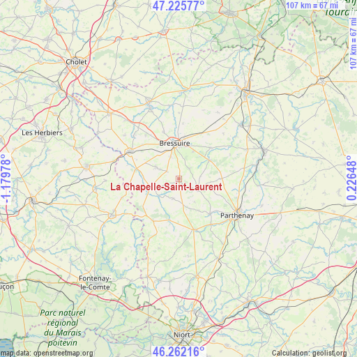
La Chapelle-Saint-Laurent GPS coordinates[2]
46° 44' 46.032" North, 0° 28' 35.94" West
| Map corner | latitude | longitude |
|---|---|---|
| Upper-left | 47.22577°, | -1.17978° |
| Center: | 46.74612°, | -0.47665° |
| Lower-right: | 46.26216°, | 0.22648° |
| Map W x H: | 107.1×107.1 km | = 66.5×66.5mi |
| max Lat: | 51.07786° ⇑57.7% North |
| La Chapelle-Saint-Laurent: | 46.74612° |
| min Lat: | ⇓42.3% South 41.3874° |
| min Long | La Chapelle-Sai | max Long |
| -5.08615° | -0.47665° | 9.52242° |
| W 16.9%⇐ | ⇒83.1% E |
Elevation
Elevation of La Chapelle-Saint-Laurent is 183 m = 600 ft, and this is 10.7 m = 35 ft below average elevation for this country.
| Max E: |
2333 m = 7654 ft | 37.3% |
| Avg. | 193.7 m = 635 ft | |
| La Chapelle-Saint-Laurent | 183 m = 600 ft | |
Min E: |
-1 m = -3 ft | 62.7% |
See also: France elevation on elevation.city.
Geographical zone
La Chapelle-Saint-Laurent is located in North temperate zone (between Tropic of Cancer and the Arctic Circle). Distance of this North polar circle is 2203.5 km =1369.2 mi to North.| Distance of | km | miles | from La Chapelle-Saint-Laurent |
|---|---|---|---|
| North Pole | 4809.4 | 2988.4 | to North |
| Arctic Circle | 2203.5 | 1369.2 | to North |
| Tropic Cancer | 2591.8 | 1610.5 | to South |
| Equator | 5197.7 | 3229.7 | to South |


Nearby cities:
15 places around La Chapelle-Saint-Laurent: (largest is in red/bold)
• Amailloux
12.2 km =7.6 mi,  89°
89°
• Boismé
4.5 km =2.8 mi,  44°
44°
• Bressuire
10.7 km =6.6 mi,  354°
354°
• Chanteloup
4.3 km =2.7 mi,  302°
302°
• Chiché
10.6 km =6.6 mi,  57°
57°
• Clessé
6.4 km =4 mi,  122°
122°
• Courlay
7.9 km =4.9 mi, 298°
• Faye-l’Abbesse
13.3 km =8.3 mi,  45°
45°
• La Forêt-sur-Sèvre
13.4 km =8.3 mi,  281°
281°
• Largeasse
6.1 km =3.8 mi,  196°
196°
• Moncoutant
8.9 km =5.5 mi,  253°
253°
• Moutiers-sous-Chantemerle
12.2 km =7.6 mi,  242°
242°
• Neuvy-Bouin
7.9 km =4.9 mi,  170°
170°
• Saint-Aubin-le-Cloud
14 km =8.7 mi,  138°
138°
• Vernoux-en-Gâtine
12.6 km =7.8 mi,  192°
192°
Sources, notices
• [Note1] Compared only with cities in France existing in our database
• [Src1] Map data: © OpenStreetMap contributors (CC-BY-SA)
• [Src2] Other city data from geonames.org with taken over terms of usage.
• [Src3] Geographical zone / Annual Mean Temperature by Robert A. Rohde @ Wikipedia
