Clessé geodata
Clessé (Nouvelle-Aquitaine) is a populated place; located in France in Europe/Paris (GMT+2) time zone. With population of 914 people, there are 9537 cities with bigger population in this country. Compared to other cities in France, 58.1% of cities are located further ↑North; 82.2% of cities are located further →East and 69.2% of cities have lower elevation than Clessé. Note1
Administrative division(s):
- Level 1: Nouvelle-Aquitaine
- Level 2: Département des Deux-Sèvres
- Level 3: Arrondissement de Bressuire
- Level 4: Clessé


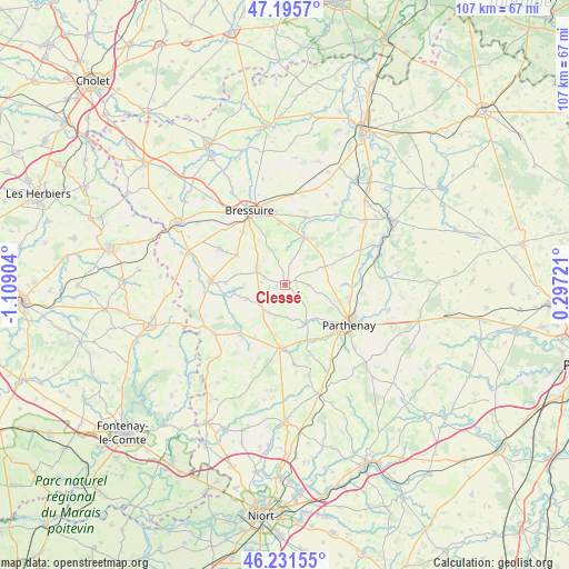
Clessé GPS coordinates[2]
46° 42' 56.808" North, 0° 24' 21.276" West
| Map corner | latitude | longitude |
|---|---|---|
| Upper-left | 47.1957°, | -1.10904° |
| Center: | 46.71578°, | -0.40591° |
| Lower-right: | 46.23155°, | 0.29721° |
| Map W x H: | 107.2×107.2 km | = 66.6×66.6mi |
| max Lat: | 51.07786° ⇑58.1% North |
| Clessé: | 46.71578° |
| min Lat: | ⇓41.9% South 41.3874° |
| min Long | Clessé | max Long |
| -5.08615° | -0.40591° | 9.52242° |
| W 17.8%⇐ | ⇒82.2% E |
Elevation
Elevation of Clessé is 215 m = 705 ft, and this is 21.3 m = 70 ft above average elevation for this country.
| Max E: |
2333 m = 7654 ft | 30.8% |
| Clessé | 215 m 705 ft | |
| Avg. | 193.7 m = 635 ft | |
Min E: |
-1 m = -3 ft | 69.2% |
See also: France elevation on elevation.city.
Geographical zone
Clessé is located in North temperate zone (between Tropic of Cancer and the Arctic Circle). Distance of this North polar circle is 2206.9 km =1371.3 mi to North.| Distance of | km | miles | from Clessé |
|---|---|---|---|
| North Pole | 4812.8 | 2990.5 | to North |
| Arctic Circle | 2206.9 | 1371.3 | to North |
| Tropic Cancer | 2588.4 | 1608.4 | to South |
| Equator | 5194.3 | 3227.6 | to South |


Nearby cities:
15 places around Clessé: (largest is in red/bold)
• Amailloux
7.6 km =4.7 mi,  63°
63°
• Azay-sur-Thouet
11 km =6.8 mi,  157°
157°
• Boismé
6.9 km =4.3 mi,  340°
340°
• Chanteloup
10.6 km =6.6 mi,  302°
302°
• Chiché
9.7 km =6 mi,  21°
21°
• Faye-l’Abbesse
13.4 km =8.3 mi, 17°
• La Chapelle-Saint-Laurent
6.4 km =4 mi, 302°
• Largeasse
7.6 km =4.7 mi,  250°
250°
• Le Tallud
12.6 km =7.8 mi,  138°
138°
• Moncoutant
14 km =8.7 mi,  273°
273°
• Neuvy-Bouin
6 km =3.7 mi,  223°
223°
• Saint-Aubin-le-Cloud
8.1 km =5 mi,  150°
150°
• Secondigny
11.8 km =7.3 mi,  184°
184°
• Vernoux-en-Gâtine
12.1 km =7.5 mi, 222°
• Viennay
12.7 km =7.9 mi,  102°
102°
Sources, notices
• [Note1] Compared only with cities in France existing in our database
• [Src1] Map data: © OpenStreetMap contributors (CC-BY-SA)
• [Src2] Other city data from geonames.org with taken over terms of usage.
• [Src3] Geographical zone / Annual Mean Temperature by Robert A. Rohde @ Wikipedia
