Chiché geodata
Chiché (Nouvelle-Aquitaine) is a populated place; located in France in Europe/Paris (GMT+2) time zone. With population of 1,459 people, there are 6335 cities with bigger population in this country. Compared to other cities in France, 57.2% of cities are located further ↑North; 81.6% of cities are located further →East and 55.9% of cities have lower elevation than Chiché. Note1
Administrative division(s):
- Level 1: Nouvelle-Aquitaine
- Level 2: Département des Deux-Sèvres
- Level 3: Arrondissement de Bressuire
- Level 4: Chiché


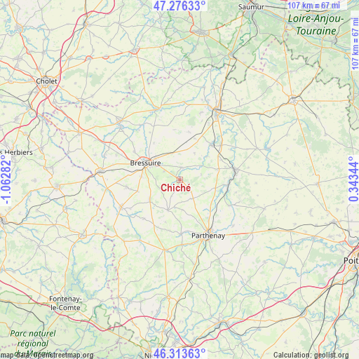
Chiché GPS coordinates[2]
46° 47' 49.668" North, 0° 21' 34.884" West
| Map corner | latitude | longitude |
|---|---|---|
| Upper-left | 47.27633°, | -1.06282° |
| Center: | 46.79713°, | -0.35969° |
| Lower-right: | 46.31363°, | 0.34344° |
| Map W x H: | 107×107 km | = 66.5×66.5mi |
| max Lat: | 51.07786° ⇑57.2% North |
| Chiché: | 46.79713° |
| min Lat: | ⇓42.8% South 41.3874° |
| min Long | Chiché | max Long |
| -5.08615° | -0.35969° | 9.52242° |
| W 18.4%⇐ | ⇒81.6% E |
Elevation
Elevation of Chiché is 153 m = 502 ft, and this is 40.7 m = 134 ft below average elevation for this country.
| Max E: |
2333 m = 7654 ft | 44.1% |
| Avg. | 193.7 m = 635 ft | |
| Chiché | 153 m = 502 ft | |
Min E: |
-1 m = -3 ft | 55.9% |
See also: France elevation on elevation.city.
Geographical zone
Chiché is located in North temperate zone (between Tropic of Cancer and the Arctic Circle). Distance of this North polar circle is 2197.8 km =1365.6 mi to North.| Distance of | km | miles | from Chiché |
|---|---|---|---|
| North Pole | 4803.7 | 2984.9 | to North |
| Arctic Circle | 2197.8 | 1365.6 | to North |
| Tropic Cancer | 2597.4 | 1613.9 | to South |
| Equator | 5203.4 | 3233.2 | to South |


Nearby cities:
15 places around Chiché: (largest is in red/bold)
• Amailloux
6.5 km =4 mi,  149°
149°
• Boismé
6.3 km =3.9 mi,  246°
246°
• Bressuire
11.1 km =6.9 mi,  296°
296°
• Chanteloup
13 km =8.1 mi, 254°
• Clessé
9.7 km =6 mi,  201°
201°
• Courlay
16 km =9.9 mi,  262°
262°
• Faye-l’Abbesse
3.7 km =2.3 mi,  8°
8°
• Glénay
10.8 km =6.7 mi,  49°
49°
• La Chapelle-Saint-Laurent
10.6 km =6.6 mi,  237°
237°
• Largeasse
15.7 km =9.8 mi,  222°
222°
• Louin
15.2 km =9.4 mi,  87°
87°
• Neuvy-Bouin
15.5 km =9.6 mi,  209°
209°
• Saint-Aubin-le-Cloud
16.1 km =10 mi,  178°
178°
• Saint-Varent
14.1 km =8.8 mi,  43°
43°
• Viennay
14.8 km =9.2 mi,  143°
143°
Sources, notices
• [Note1] Compared only with cities in France existing in our database
• [Src1] Map data: © OpenStreetMap contributors (CC-BY-SA)
• [Src2] Other city data from geonames.org with taken over terms of usage.
• [Src3] Geographical zone / Annual Mean Temperature by Robert A. Rohde @ Wikipedia
