Alban geodata
Alban (Occitanie) is a populated place; located in France in Europe/Paris (GMT+2) time zone. With population of 928 people, there are 9405 cities with bigger population in this country. Compared to other cities in France, 88.2% of cities are located further ↑North; 50% of cities are located further ←West and 95.6% of cities have lower elevation than Alban. Note1


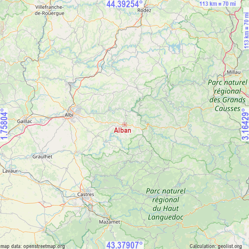
Alban GPS coordinates[2]
43° 53' 16.656" North, 2° 27' 40.176" East
| Map corner | latitude | longitude |
|---|---|---|
| Upper-left | 44.39254°, | 1.75804° |
| Center: | 43.88796°, | 2.46116° |
| Lower-right: | 43.37907°, | 3.16429° |
| Map W x H: | 112.7×112.7 km | = 70×70mi |
| max Lat: | 51.07786° ⇑88.2% North |
| Alban: | 43.88796° |
| min Lat: | ⇓11.8% South 41.3874° |
| min Long | Alban | max Long |
| -5.08615° | 2.46116° | 9.52242° |
| W 50%⇐ | ⇒50% E |
Elevation
Elevation of Alban is 617 m = 2024 ft, and this is 423.3 m = 1389 ft above average elevation for this country.
| Max E: |
2333 m = 7654 ft | 4.4% |
| Alban | 617 m 2024 ft | |
| Avg. | 193.7 m = 635 ft | |
Min E: |
-1 m = -3 ft | 95.6% |
See also: France elevation on elevation.city.
Geographical zone
Alban is located in North temperate zone (between Tropic of Cancer and the Arctic Circle). Distance of this Northern Tropic circle is 2274 km =1413 mi to South.| Distance of | km | miles | from Alban |
|---|---|---|---|
| North Pole | 5127.2 | 3185.9 | to North |
| Arctic Circle | 2521.3 | 1566.7 | to North |
| Tropic Cancer | 2274 | 1413 | to South |
| Equator | 4879.9 | 3032.2 | to South |


Nearby cities:
15 places around Alban: (largest is in red/bold)
• Arthès
21.5 km =13.4 mi,  291°
291°
• Coupiac
12.2 km =7.6 mi,  52°
52°
• Cunac
20 km =12.4 mi,  283°
283°
• Curvalle
8.2 km =5.1 mi,  57°
57°
• Dénat
21 km =13 mi,  257°
257°
• Fréjairolles
18.4 km =11.4 mi,  267°
267°
• Montredon-Labessonnié
21.9 km =13.6 mi,  210°
210°
• Paulinet
5 km =3.1 mi, 208°
• Réquista
17.2 km =10.7 mi,  20°
20°
• Saint-Juéry
20.8 km =12.9 mi, 289°
• Saint-Pierre-de-Trivisy
14.3 km =8.9 mi,  188°
188°
• Saint-Sernin-sur-Rance
11.5 km =7.1 mi,  91°
91°
• Valence-d’Albigeois
15.3 km =9.5 mi,  342°
342°
• Viane
19.6 km =12.2 mi,  149°
149°
• Villefranche-d'Albigeois
10.5 km =6.5 mi, 275°
Sources, notices
• [Note1] Compared only with cities in France existing in our database
• [Src1] Map data: © OpenStreetMap contributors (CC-BY-SA)
• [Src2] Other city data from geonames.org with taken over terms of usage.
• [Src3] Geographical zone / Annual Mean Temperature by Robert A. Rohde @ Wikipedia
