Montredon-Labessonnié geodata
Montredon-Labessonnié (Occitanie) is a populated place; located in France in Europe/Paris (GMT+2) time zone. With population of 2,137 people, there are 4498 cities with bigger population in this country. Compared to other cities in France, 90.2% of cities are located further ↑North; 52.3% of cities are located further →East and 93.3% of cities have lower elevation than Montredon-Labessonnié. Note1
Administrative division(s):
- Level 1: Occitanie
- Level 2: Tarn
- Level 3: Arrondissement de Castres
- Level 4: Montredon-Labessonnié
Current local time in Montredon-Labessonnié:
08:36 PM, SaturdayDifference from your time zone: hours


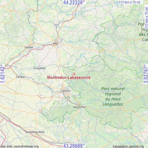
Montredon-Labessonnié GPS coordinates[2]
43° 43' 2.028" North, 2° 19' 28.344" East
| Map corner | latitude | longitude |
|---|---|---|
| Upper-left | 44.22326°, | 1.62142° |
| Center: | 43.71723°, | 2.32454° |
| Lower-right: | 43.20689°, | 3.02767° |
| Map W x H: | 113×113 km | = 70.2×70.2mi |
| max Lat: | 51.07786° ⇑90.2% North |
| Montredon-Labessonnié: | 43.71723° |
| min Lat: | ⇓9.8% South 41.3874° |
| min Long | Montredon-Labes | max Long |
| -5.08615° | 2.32454° | 9.52242° |
| W 47.7%⇐ | ⇒52.3% E |
Elevation
Elevation of Montredon-Labessonnié is 517 m = 1696 ft, and this is 323.3 m = 1061 ft above average elevation for this country.
| Max E: |
2333 m = 7654 ft | 6.7% |
| Montredon-Labessonnié | 517 m 1696 ft | |
| Avg. | 193.7 m = 635 ft | |
Min E: |
-1 m = -3 ft | 93.3% |
See also: France elevation on elevation.city.
Geographical zone
Montredon-Labessonnié is located in North temperate zone (between Tropic of Cancer and the Arctic Circle). Distance of this Northern Tropic circle is 2255 km =1401.2 mi to South.| Distance of | km | miles | from Montredon-Labessonnié |
|---|---|---|---|
| North Pole | 5146.2 | 3197.7 | to North |
| Arctic Circle | 2540.3 | 1578.5 | to North |
| Tropic Cancer | 2255 | 1401.2 | to South |
| Equator | 4860.9 | 3020.4 | to South |


Nearby cities:
15 places around Montredon-Labessonnié: (largest is in red/bold)
• Burlats
9 km =5.6 mi,  182°
182°
• Castres
14.1 km =8.8 mi,  208°
208°
• Lacrouzette
6.6 km =4.1 mi,  163°
163°
• Lagarrigue
16 km =9.9 mi,  193°
193°
• Lautrec
14.9 km =9.3 mi,  265°
265°
• Lombers
16.8 km =10.4 mi,  303°
303°
• Noailhac
16.2 km =10.1 mi,  171°
171°
• Paulinet
17 km =10.6 mi,  30°
30°
• Roquecourbe
6.4 km =4 mi,  203°
203°
• Réalmont
12.8 km =8 mi, 301°
• Saint-Pierre-de-Trivisy
10.1 km =6.3 mi,  60°
60°
• Saint-Salvy-de-la-Balme
13.2 km =8.2 mi,  153°
153°
• Vabre
8.5 km =5.3 mi,  109°
109°
• Valdurenque
16.5 km =10.3 mi, 185°
• Vénès
10.7 km =6.6 mi,  276°
276°
Sources, notices
• [Note1] Compared only with cities in France existing in our database
• [Src1] Map data: © OpenStreetMap contributors (CC-BY-SA)
• [Src2] Other city data from geonames.org with taken over terms of usage.
• [Src3] Geographical zone / Annual Mean Temperature by Robert A. Rohde @ Wikipedia
