Curvalle geodata
Curvalle (Occitanie) is a populated place; located in France in Europe/Paris (GMT+2) time zone. With population of 519 people, there are 14840 cities with bigger population in this country. Compared to other cities in France, 87.8% of cities are located further ↑North; 51.3% of cities are located further ←West and 74.3% of cities have lower elevation than Curvalle. Note1


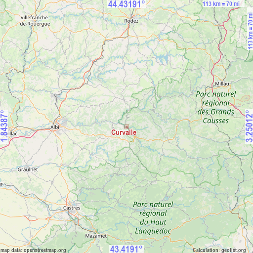
Curvalle GPS coordinates[2]
43° 55' 39.576" North, 2° 32' 49.2" East
| Map corner | latitude | longitude |
|---|---|---|
| Upper-left | 44.43191°, | 1.84387° |
| Center: | 43.92766°, | 2.547° |
| Lower-right: | 43.4191°, | 3.25012° |
| Map W x H: | 112.6×112.6 km | = 70×70mi |
| max Lat: | 51.07786° ⇑87.8% North |
| Curvalle: | 43.92766° |
| min Lat: | ⇓12.2% South 41.3874° |
| min Long | Curvalle | max Long |
| -5.08615° | 2.547° | 9.52242° |
| W 51.3%⇐ | ⇒48.7% E |
Elevation
Elevation of Curvalle is 244 m = 801 ft, and this is 50.3 m = 165 ft above average elevation for this country.
| Max E: |
2333 m = 7654 ft | 25.7% |
| Curvalle | 244 m 801 ft | |
| Avg. | 193.7 m = 635 ft | |
Min E: |
-1 m = -3 ft | 74.3% |
See also: France elevation on elevation.city.
Geographical zone
Curvalle is located in North temperate zone (between Tropic of Cancer and the Arctic Circle). Distance of this Northern Tropic circle is 2278.4 km =1415.7 mi to South.| Distance of | km | miles | from Curvalle |
|---|---|---|---|
| North Pole | 5122.8 | 3183.2 | to North |
| Arctic Circle | 2516.9 | 1563.9 | to North |
| Tropic Cancer | 2278.4 | 1415.7 | to South |
| Equator | 4884.3 | 3035 | to South |


Nearby cities:
15 places around Curvalle: (largest is in red/bold)
• Alban
8.2 km =5.1 mi,  237°
237°
• Belmont-sur-Rance
20.6 km =12.8 mi,  125°
125°
• Broquiès
14.7 km =9.1 mi,  54°
54°
• Coupiac
4.1 km =2.5 mi,  44°
44°
• Durenque
21 km =13 mi,  15°
15°
• La Selve
20.6 km =12.8 mi,  358°
358°
• Lédergues
19.8 km =12.3 mi,  334°
334°
• Paulinet
12.7 km =7.9 mi,  226°
226°
• Réquista
11.8 km =7.3 mi, 355°
• Saint-Pierre-de-Trivisy
20.6 km =12.8 mi,  206°
206°
• Saint-Sernin-sur-Rance
6.6 km =4.1 mi,  135°
135°
• Valence-d’Albigeois
15.2 km =9.4 mi,  311°
311°
• Viane
21.5 km =13.4 mi,  171°
171°
• Villefranche-d'Albigeois
17.7 km =11 mi,  258°
258°
• Villefranche-de-Panat
22 km =13.7 mi, 35°
Sources, notices
• [Note1] Compared only with cities in France existing in our database
• [Src1] Map data: © OpenStreetMap contributors (CC-BY-SA)
• [Src2] Other city data from geonames.org with taken over terms of usage.
• [Src3] Geographical zone / Annual Mean Temperature by Robert A. Rohde @ Wikipedia
