Réquista geodata
Réquista (Occitanie) is a populated place; located in France in Europe/Paris (GMT+2) time zone. With population of 2,107 people, there are 4577 cities with bigger population in this country. Compared to other cities in France, 86.8% of cities are located further ↑North; 51.2% of cities are located further ←West and 94.6% of cities have lower elevation than Réquista. Note1
Administrative division(s):
- Level 1: Occitanie
- Level 2: Département de l'Aveyron
- Level 3: Arrondissement de Millau
- Level 4: Réquista


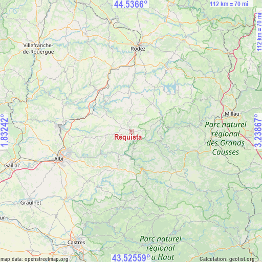
Réquista GPS coordinates[2]
44° 1' 59.7" North, 2° 32' 7.944" East
| Map corner | latitude | longitude |
|---|---|---|
| Upper-left | 44.5366°, | 1.83242° |
| Center: | 44.03325°, | 2.53554° |
| Lower-right: | 43.52559°, | 3.23867° |
| Map W x H: | 112.4×112.4 km | = 69.8×69.8mi |
| max Lat: | 51.07786° ⇑86.8% North |
| Réquista: | 44.03325° |
| min Lat: | ⇓13.2% South 41.3874° |
| min Long | Réquista | max Long |
| -5.08615° | 2.53554° | 9.52242° |
| W 51.2%⇐ | ⇒48.8% E |
Elevation
Elevation of Réquista is 563 m = 1847 ft, and this is 369.3 m = 1212 ft above average elevation for this country.
| Max E: |
2333 m = 7654 ft | 5.4% |
| Réquista | 563 m 1847 ft | |
| Avg. | 193.7 m = 635 ft | |
Min E: |
-1 m = -3 ft | 94.6% |
See also: France elevation on elevation.city.
Geographical zone
Réquista is located in North temperate zone (between Tropic of Cancer and the Arctic Circle). Distance of this Northern Tropic circle is 2290.1 km =1423 mi to South.| Distance of | km | miles | from Réquista |
|---|---|---|---|
| North Pole | 5111 | 3175.8 | to North |
| Arctic Circle | 2505.1 | 1556.6 | to North |
| Tropic Cancer | 2290.1 | 1423 | to South |
| Equator | 4896 | 3042.2 | to South |


Nearby cities:
15 places around Réquista: (largest is in red/bold)
• Alban
17.2 km =10.7 mi,  200°
200°
• Arvieu
20.3 km =12.6 mi,  29°
29°
• Broquiès
13.3 km =8.3 mi,  103°
103°
• Cassagnes-Bégonhès
15.1 km =9.4 mi,  358°
358°
• Centrès
17.7 km =11 mi,  325°
325°
• Coupiac
9.6 km =6 mi,  157°
157°
• Curvalle
11.8 km =7.3 mi,  175°
175°
• Durenque
10.8 km =6.7 mi,  38°
38°
• La Selve
8.8 km =5.5 mi,  1°
1°
• Lédergues
9.7 km =6 mi,  309°
309°
• Saint-Sernin-sur-Rance
17.4 km =10.8 mi, 161°
• Salmiech
16.8 km =10.4 mi,  10°
10°
• Tanus
19 km =11.8 mi,  293°
293°
• Valence-d’Albigeois
10.5 km =6.5 mi,  261°
261°
• Villefranche-de-Panat
14.9 km =9.3 mi,  65°
65°
Sources, notices
• [Note1] Compared only with cities in France existing in our database
• [Src1] Map data: © OpenStreetMap contributors (CC-BY-SA)
• [Src2] Other city data from geonames.org with taken over terms of usage.
• [Src3] Geographical zone / Annual Mean Temperature by Robert A. Rohde @ Wikipedia
