Viane geodata
Viane (Occitanie) is a populated place; located in France in Europe/Paris (GMT+2) time zone. With population of 661 people, there are 12375 cities with bigger population in this country. Compared to other cities in France, 89.9% of cities are located further ↑North; 51.9% of cities are located further ←West and 93.1% of cities have lower elevation than Viane. Note1
Administrative division(s):
- Level 1: Occitanie
- Level 2: Tarn
- Level 3: Arrondissement de Castres
- Level 4: Viane


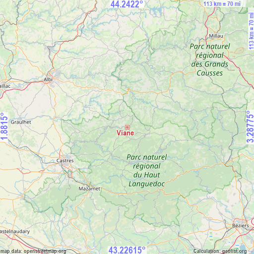
Viane GPS coordinates[2]
43° 44' 10.788" North, 2° 35' 4.632" East
| Map corner | latitude | longitude |
|---|---|---|
| Upper-left | 44.2422°, | 1.8815° |
| Center: | 43.73633°, | 2.58462° |
| Lower-right: | 43.22615°, | 3.28775° |
| Map W x H: | 113×113 km | = 70.2×70.2mi |
| max Lat: | 51.07786° ⇑89.9% North |
| Viane: | 43.73633° |
| min Lat: | ⇓10.1% South 41.3874° |
| min Long | Viane | max Long |
| -5.08615° | 2.58462° | 9.52242° |
| W 51.9%⇐ | ⇒48.1% E |
Elevation
Elevation of Viane is 509 m = 1670 ft, and this is 315.3 m = 1034 ft above average elevation for this country.
| Max E: |
2333 m = 7654 ft | 6.9% |
| Viane | 509 m 1670 ft | |
| Avg. | 193.7 m = 635 ft | |
Min E: |
-1 m = -3 ft | 93.1% |
See also: France elevation on elevation.city.
Geographical zone
Viane is located in North temperate zone (between Tropic of Cancer and the Arctic Circle). Distance of this Northern Tropic circle is 2257.1 km =1402.5 mi to South.| Distance of | km | miles | from Viane |
|---|---|---|---|
| North Pole | 5144 | 3196.3 | to North |
| Arctic Circle | 2538.2 | 1577.2 | to North |
| Tropic Cancer | 2257.1 | 1402.5 | to South |
| Equator | 4863 | 3021.7 | to South |


Nearby cities:
15 places around Viane: (largest is in red/bold)
• Alban
19.6 km =12.2 mi,  329°
329°
• Anglès
19.3 km =12 mi,  185°
185°
• Belmont-sur-Rance
16.5 km =10.3 mi,  55°
55°
• Brassac
13.8 km =8.6 mi,  210°
210°
• Castelnau-de-Brassac
11.2 km =7 mi, 209°
• La Salvetat-sur-Agout
18.5 km =11.5 mi,  144°
144°
• Lacaune
9.3 km =5.8 mi,  110°
110°
• Lacrouzette
20.8 km =12.9 mi,  246°
246°
• Le Bez
16.9 km =10.5 mi, 211°
• Montredon-Labessonnié
21 km =13 mi,  264°
264°
• Paulinet
17.5 km =10.9 mi,  315°
315°
• Saint-Pierre-de-Trivisy
12.4 km =7.7 mi,  282°
282°
• Saint-Salvy-de-la-Balme
20.4 km =12.7 mi,  227°
227°
• Saint-Sernin-sur-Rance
16.6 km =10.3 mi,  5°
5°
• Vabre
13.8 km =8.6 mi, 248°
Sources, notices
• [Note1] Compared only with cities in France existing in our database
• [Src1] Map data: © OpenStreetMap contributors (CC-BY-SA)
• [Src2] Other city data from geonames.org with taken over terms of usage.
• [Src3] Geographical zone / Annual Mean Temperature by Robert A. Rohde @ Wikipedia
