Bala geodata
Bala (Wales) is a populated place; located in United Kingdom in Europe/London (GMT+1) time zone. With population of 1,974 people, there are 2644 cities with bigger population in this country. Compared to other cities in United Kingdom, 59.2% of cities are located further ↓South; 83.6% of cities are located further →East and 93.3% of cities have lower elevation than Bala. Note1


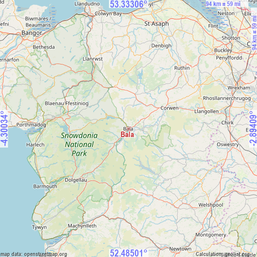
Bala GPS coordinates[2]
52° 54' 39.996" North, 3° 35' 49.992" West
| Map corner | latitude | longitude |
|---|---|---|
| Upper-left | 53.33306°, | -4.30034° |
| Center: | 52.91111°, | -3.59722° |
| Lower-right: | 52.48501°, | -2.89409° |
| Map W x H: | 94.3×94.3 km | = 58.6×58.6mi |
| max Lat: | 60.39635° ⇑40.8% North |
| Bala: | 52.91111° |
| min Lat: | ⇓59.2% South 34.60088° |
| min Long | Bala | max Long |
| -7.64133° | -3.59722° | 32.95536° |
| W 16.4%⇐ | ⇒83.6% E |
Elevation
Elevation of Bala is 168 m = 551 ft, and this is 95.1 m = 312 ft above average elevation for this country.
| Max E: |
515 m = 1690 ft | 6.7% |
| Bala | 168 m 551 ft | |
| Avg. | 72.9 m = 239 ft | |
Min E: |
-30 m = -98 ft | 93.3% |
See also: United Kingdom elevation on elevation.city.
Geographical zone
Bala is located in North temperate zone (between Tropic of Cancer and the Arctic Circle). Distance of this North polar circle is 1518 km =943.2 mi to North.| Distance of | km | miles | from Bala |
|---|---|---|---|
| North Pole | 4123.9 | 2562.5 | to North |
| Arctic Circle | 1518 | 943.2 | to North |
| Tropic Cancer | 3277.2 | 2036.4 | to South |
| Equator | 5883.2 | 3655.6 | to South |


Nearby cities:
15 places around Bala: (largest is in red/bold)
• Betws-y-Coed
24.7 km =15.3 mi,  325°
325°
• Blaenau-Ffestiniog
24.6 km =15.3 mi,  292°
292°
• Bryneglwys
24.1 km =15 mi,  60°
60°
• Cynwyd
13.9 km =8.6 mi,  67°
67°
• Derwen
18.9 km =11.7 mi,  44°
44°
• Dolgellau
27 km =16.8 mi,  225°
225°
• Ffestiniog
23.1 km =14.4 mi,  283°
283°
• Llan Ffestiniog
22.9 km =14.2 mi, 283°
• Llandrillo
10.8 km =6.7 mi,  83°
83°
• Llanfyllin
27.2 km =16.9 mi,  126°
126°
• Llangwm
9.1 km =5.7 mi,  28°
28°
• Llangynog
15.8 km =9.8 mi,  123°
123°
• Llanrhaeadr-ym-Mochnant
22 km =13.7 mi, 115°
• Maentwrog
26.5 km =16.5 mi, 278°
• Trawsfynydd
21.9 km =13.6 mi,  267°
267°
Sources, notices
• [Note1] Compared only with cities in United Kingdom existing in our database
• [Src1] Map data: © OpenStreetMap contributors (CC-BY-SA)
• [Src2] Other city data from geonames.org with taken over terms of usage.
• [Src3] Geographical zone / Annual Mean Temperature by Robert A. Rohde @ Wikipedia
