Abastumani geodata
Abastumani (Samtskhe-Javakheti) is a populated place; located in Georgia in Asia/Tbilisi (GMT+4) time zone. With population of 1,285 people, there are 94 cities with bigger population in this country. Compared to other cities in Georgia, 74.4% of cities are located further ↑North; 57.3% of cities are located further →East and 89.7% of cities have lower elevation than Abastumani. Note1


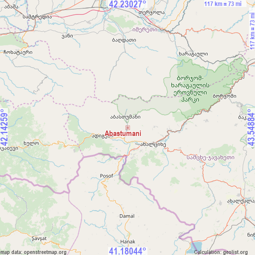
Abastumani GPS coordinates[2]
41° 42' 27" North, 42° 50' 44.556" East
| Map corner | latitude | longitude |
|---|---|---|
| Upper-left | 42.23027°, | 42.14259° |
| Center: | 41.7075°, | 42.84571° |
| Lower-right: | 41.18044°, | 43.54884° |
| Map W x H: | 116.7×116.7 km | = 72.5×72.5mi |
| max Lat: | 43.38111° ⇑74.4% North |
| Abastumani: | 41.7075° |
| min Lat: | ⇓25.6% South 41.21725° |
| min Long | Abastumani | max Long |
| 40.07944° | 42.84571° | 46.27667° |
| W 42.7%⇐ | ⇒57.3% E |
Elevation
Elevation of Abastumani is 1203 m = 3947 ft, and this is 624.2 m = 2048 ft above average elevation for this country.
| Max E: |
2223 m = 7293 ft | 10.3% |
| Abastumani | 1203 m 3947 ft | |
| Avg. | 578.8 m = 1899 ft | |
Min E: |
1 m = 3 ft | 89.7% |
See also: Georgia elevation on elevation.city.
Geographical zone
Abastumani is located in North temperate zone (between Tropic of Cancer and the Arctic Circle). Distance of this Northern Tropic circle is 2031.5 km =1262.3 mi to South.| Distance of | km | miles | from Abastumani |
|---|---|---|---|
| North Pole | 5369.6 | 3336.5 | to North |
| Arctic Circle | 2763.7 | 1717.3 | to North |
| Tropic Cancer | 2031.5 | 1262.3 | to South |
| Equator | 4637.4 | 2881.5 | to South |


Nearby cities:
15 places around Abastumani: (largest is in red/bold)
• Adigeni
12.5 km =7.8 mi,  256°
256°
• Akhaltsikhe
13.7 km =8.5 mi,  123°
123°
• Aspindza
36.6 km =22.7 mi,  113°
113°
• Bakurianis Andeziti
52.1 km =32.4 mi,  86°
86°
• Borjomi
49.7 km =30.9 mi,  71°
71°
• Dioknisi
38.7 km =24 mi, 257°
• Kharagauli
45.5 km =28.3 mi,  39°
39°
• Khert’visi
44.6 km =27.7 mi, 124°
• Khulo
45.6 km =28.3 mi, 261°
• Shorapani
47 km =29.2 mi,  25°
25°
• Shuakhevi
55.1 km =34.2 mi, 260°
• Tsaghveri
53.8 km =33.4 mi,  78°
78°
• Vale
10.5 km =6.5 mi,  167°
167°
• Vani
49.6 km =30.8 mi,  327°
327°
• Zestap’oni
47.9 km =29.8 mi,  20°
20°
Sources, notices
• [Note1] Compared only with cities in Georgia existing in our database
• [Src1] Map data: © OpenStreetMap contributors (CC-BY-SA)
• [Src2] Other city data from geonames.org with taken over terms of usage.
• [Src3] Geographical zone / Annual Mean Temperature by Robert A. Rohde @ Wikipedia
