Zestap’oni geodata
Zestap’oni (Imereti) is a seat of a second-order administrative division; located in Georgia in Asia/Tbilisi (GMT+4) time zone. With population of 25,891 people, there are 13 cities with bigger population in this country. Compared to other cities in Georgia, 57.3% of cities are located further ↓South; 53.8% of cities are located further →East and 65.8% of cities have higher elevation than Zestap’oni. Note1


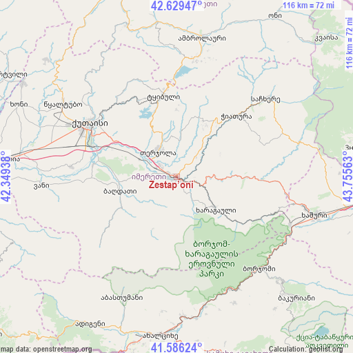
Zestap’oni GPS coordinates[2]
42° 6' 36" North, 43° 3' 9" East
| Map corner | latitude | longitude |
|---|---|---|
| Upper-left | 42.62947°, | 42.34938° |
| Center: | 42.11°, | 43.0525° |
| Lower-right: | 41.58624°, | 43.75563° |
| Map W x H: | 116×116 km | = 72.1×72.1mi |
| max Lat: | 43.38111° ⇑42.7% North |
| Zestap’oni: | 42.11° |
| min Lat: | ⇓57.3% South 41.21725° |
| min Long | Zestap’oni | max Long |
| 40.07944° | 43.0525° | 46.27667° |
| W 46.2%⇐ | ⇒53.8% E |
Elevation
Elevation of Zestap’oni is 201 m = 659 ft, and this is 377.8 m = 1240 ft below average elevation for this country.
| Max E: |
2223 m = 7293 ft | 65.8% |
| Avg. | 578.8 m = 1899 ft | |
| Zestap’oni | 201 m = 659 ft | |
Min E: |
1 m = 3 ft | 34.2% |
See also: Georgia elevation on elevation.city.
Geographical zone
Zestap’oni is located in North temperate zone (between Tropic of Cancer and the Arctic Circle). Distance of this Northern Tropic circle is 2076.3 km =1290.2 mi to South.| Distance of | km | miles | from Zestap’oni |
|---|---|---|---|
| North Pole | 5324.9 | 3308.7 | to North |
| Arctic Circle | 2719 | 1689.5 | to North |
| Tropic Cancer | 2076.3 | 1290.2 | to South |
| Equator | 4682.2 | 2909.4 | to South |


Nearby cities:
15 places around Zestap’oni: (largest is in red/bold)
• Akhaldaba
41.2 km =25.6 mi,  119°
119°
• Ambrolauri
46.6 km =29 mi,  11°
11°
• Borjomi
41.3 km =25.7 mi,  133°
133°
• Chiat’ura
29.1 km =18.1 mi,  44°
44°
• Gori
46.2 km =28.7 mi, 11°
• Kats’khi
24 km =14.9 mi,  32°
32°
• Kharagauli
15.5 km =9.6 mi, 129°
• Khashuri
47 km =29.2 mi,  105°
105°
• Kutaisi
34.3 km =21.3 mi,  300°
300°
• Sach’khere
40 km =24.9 mi,  49°
49°
• Shorapani
3.6 km =2.2 mi, 128°
• Surami
42.6 km =26.5 mi,  102°
102°
• Tqibuli
27.2 km =16.9 mi,  350°
350°
• Tsqaltubo
45.4 km =28.2 mi, 304°
• Vani
43.9 km =27.3 mi,  266°
266°
Sources, notices
• [Note1] Compared only with cities in Georgia existing in our database
• [Src1] Map data: © OpenStreetMap contributors (CC-BY-SA)
• [Src2] Other city data from geonames.org with taken over terms of usage.
• [Src3] Geographical zone / Annual Mean Temperature by Robert A. Rohde @ Wikipedia
