Lanchkhuti geodata
Lanchkhuti (Guria) is a seat of a second-order administrative division; located in Georgia in Asia/Tbilisi (GMT+4) time zone. In our database, there are 111 cities with bigger population. Compared to other cities in Georgia, 55.6% of cities are located further ↓South; 74.4% of cities are located further →East and 85.5% of cities have higher elevation than Lanchkhuti. Note1


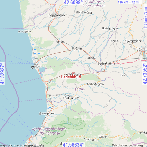
Lanchkhuti GPS coordinates[2]
42° 5' 24.972" North, 42° 1' 56.604" East
| Map corner | latitude | longitude |
|---|---|---|
| Upper-left | 42.6099°, | 41.32927° |
| Center: | 42.09027°, | 42.03239° |
| Lower-right: | 41.56634°, | 42.73552° |
| Map W x H: | 116×116 km | = 72.1×72.1mi |
| max Lat: | 43.38111° ⇑44.4% North |
| Lanchkhuti: | 42.09027° |
| min Lat: | ⇓55.6% South 41.21725° |
| min Long | Lanchkhuti | max Long |
| 40.07944° | 42.03239° | 46.27667° |
| W 25.6%⇐ | ⇒74.4% E |
Elevation
Elevation of Lanchkhuti is 22 m = 72 ft, and this is 556.8 m = 1827 ft below average elevation for this country.
| Max E: |
2223 m = 7293 ft | 85.5% |
| Avg. | 578.8 m = 1899 ft | |
| Lanchkhuti | 22 m = 72 ft | |
Min E: |
1 m = 3 ft | 14.5% |
See also: Georgia elevation on elevation.city.
Geographical zone
Lanchkhuti is located in North temperate zone (between Tropic of Cancer and the Arctic Circle). Distance of this Northern Tropic circle is 2074.1 km =1288.8 mi to South.| Distance of | km | miles | from Lanchkhuti |
|---|---|---|---|
| North Pole | 5327.1 | 3310.1 | to North |
| Arctic Circle | 2721.2 | 1690.9 | to North |
| Tropic Cancer | 2074.1 | 1288.8 | to South |
| Equator | 4680 | 2908 | to South |


Nearby cities:
15 places around Lanchkhuti: (largest is in red/bold)
• Abasha
20.4 km =12.7 mi,  49°
49°
• Khobi
27.4 km =17 mi,  336°
336°
• Khoni
41.1 km =25.5 mi, 51°
• Kobuleti
36.5 km =22.7 mi,  215°
215°
• Kveda Chkhorots’q’u
43.8 km =27.2 mi,  6°
6°
• K’ulashi
28.6 km =17.8 mi,  63°
63°
• Naruja
21.4 km =13.3 mi,  197°
197°
• Ochkhamuri
29.6 km =18.4 mi,  210°
210°
• Ozurgeti
18.6 km =11.6 mi,  186°
186°
• P’ot’i
30.4 km =18.9 mi,  281°
281°
• Samtredia
25.9 km =16.1 mi,  74°
74°
• Senak’i
20.2 km =12.6 mi, 8°
• Tsikhisdziri
42.7 km =26.5 mi, 212°
• Urek’i
23.5 km =14.6 mi,  243°
243°
• Vani
40.4 km =25.1 mi,  91°
91°
Sources, notices
• [Note1] Compared only with cities in Georgia existing in our database
• [Src1] Map data: © OpenStreetMap contributors (CC-BY-SA)
• [Src2] Other city data from geonames.org with taken over terms of usage.
• [Src3] Geographical zone / Annual Mean Temperature by Robert A. Rohde @ Wikipedia
