Zugdidi geodata
Zugdidi (Samegrelo and Zemo Svaneti) is a seat of a first-order administrative division; located in Georgia in Asia/Tbilisi (GMT+4) time zone. With population of 73,006 people, there are 4 cities with bigger population in this country. Compared to other cities in Georgia, 79.5% of cities are located further ↓South; 78.6% of cities are located further →East and 72.6% of cities have higher elevation than Zugdidi. Note1
Administrative division(s):
- Level 1: Samegrelo and Zemo Svaneti
- Level 2: Zugdidis Munitsip’alit’et’i


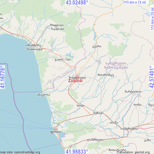
Zugdidi GPS coordinates[2]
42° 30' 31.68" North, 41° 52' 15.168" East
| Map corner | latitude | longitude |
|---|---|---|
| Upper-left | 43.02498°, | 41.16776° |
| Center: | 42.5088°, | 41.87088° |
| Lower-right: | 41.98833°, | 42.57401° |
| Map W x H: | 115.3×115.3 km | = 71.6×71.6mi |
| max Lat: | 43.38111° ⇑20.5% North |
| Zugdidi: | 42.5088° |
| min Lat: | ⇓79.5% South 41.21725° |
| min Long | Zugdidi | max Long |
| 40.07944° | 41.87088° | 46.27667° |
| W 21.4%⇐ | ⇒78.6% E |
Elevation
Elevation of Zugdidi is 111 m = 364 ft, and this is 467.8 m = 1535 ft below average elevation for this country.
| Max E: |
2223 m = 7293 ft | 72.6% |
| Avg. | 578.8 m = 1899 ft | |
| Zugdidi | 111 m = 364 ft | |
Min E: |
1 m = 3 ft | 27.4% |
See also: Zugdidi elevation on elevation.city.
Geographical zone
Zugdidi is located in North temperate zone (between Tropic of Cancer and the Arctic Circle). Distance of this Northern Tropic circle is 2120.6 km =1317.7 mi to South.| Distance of | km | miles | from Zugdidi |
|---|---|---|---|
| North Pole | 5280.5 | 3281.1 | to North |
| Arctic Circle | 2674.6 | 1661.9 | to North |
| Tropic Cancer | 2120.6 | 1317.7 | to South |
| Equator | 4726.5 | 2936.9 | to South |


Nearby cities:
15 places around Zugdidi: (largest is in red/bold)
• Abasha
44 km =27.3 mi,  139°
139°
• Gali
17 km =10.6 mi,  320°
320°
• Jvari
27.5 km =17.1 mi,  32°
32°
• Khobi
21.6 km =13.4 mi,  173°
173°
• Khoni
49.6 km =30.8 mi,  114°
114°
• Kveda Chkhorots’q’u
18.8 km =11.7 mi,  99°
99°
• Lanchkhuti
48.4 km =30.1 mi,  164°
164°
• Mart’vili
43 km =26.7 mi, 104°
• Mokvi
46.5 km =28.9 mi, 316°
• Och’amch’ire
39.9 km =24.8 mi,  304°
304°
• Orsant’ia
16.8 km =10.4 mi,  254°
254°
• P’ot’i
43.5 km =27 mi,  202°
202°
• Senak’i
31 km =19.3 mi,  148°
148°
• Tqvarch'eli
40 km =24.9 mi,  337°
337°
• Tsalenjikha
19.3 km =12 mi,  56°
56°
Sources, notices
• [Note1] Compared only with cities in Georgia existing in our database
• [Src1] Map data: © OpenStreetMap contributors (CC-BY-SA)
• [Src2] Other city data from geonames.org with taken over terms of usage.
• [Src3] Geographical zone / Annual Mean Temperature by Robert A. Rohde @ Wikipedia
