Tsalenjikha geodata
Tsalenjikha (Samegrelo and Zemo Svaneti) is a populated place; located in Georgia in Asia/Tbilisi (GMT+4) time zone. With population of 8,879 people, there are 37 cities with bigger population in this country. Compared to other cities in Georgia, 82.9% of cities are located further ↓South; 71.8% of cities are located further →East and 67.5% of cities have higher elevation than Tsalenjikha. Note1


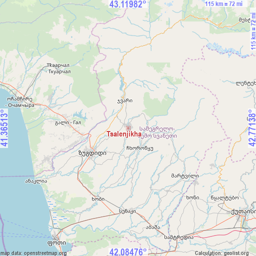
Tsalenjikha GPS coordinates[2]
42° 36' 15.984" North, 42° 4' 5.7" East
| Map corner | latitude | longitude |
|---|---|---|
| Upper-left | 43.11982°, | 41.36513° |
| Center: | 42.60444°, | 42.06825° |
| Lower-right: | 42.08476°, | 42.77138° |
| Map W x H: | 115.1×115.1 km | = 71.5×71.5mi |
| max Lat: | 43.38111° ⇑17.1% North |
| Tsalenjikha: | 42.60444° |
| min Lat: | ⇓82.9% South 41.21725° |
| min Long | Tsalenjikha | max Long |
| 40.07944° | 42.06825° | 46.27667° |
| W 28.2%⇐ | ⇒71.8% E |
Elevation
Elevation of Tsalenjikha is 179 m = 587 ft, and this is 399.8 m = 1312 ft below average elevation for this country.
| Max E: |
2223 m = 7293 ft | 67.5% |
| Avg. | 578.8 m = 1899 ft | |
| Tsalenjikha | 179 m = 587 ft | |
Min E: |
1 m = 3 ft | 32.5% |
See also: Georgia elevation on elevation.city.
Geographical zone
Tsalenjikha is located in North temperate zone (between Tropic of Cancer and the Arctic Circle). Distance of this Northern Tropic circle is 2131.3 km =1324.3 mi to South.| Distance of | km | miles | from Tsalenjikha |
|---|---|---|---|
| North Pole | 5269.9 | 3274.6 | to North |
| Arctic Circle | 2664 | 1655.3 | to North |
| Tropic Cancer | 2131.3 | 1324.3 | to South |
| Equator | 4737.2 | 2943.6 | to South |


Nearby cities:
15 places around Tsalenjikha: (largest is in red/bold)
• Abasha
45.7 km =28.4 mi,  164°
164°
• Gali
27.1 km =16.8 mi,  275°
275°
• Jvari
12.6 km =7.8 mi,  353°
353°
• Khobi
35 km =21.7 mi,  203°
203°
• Khoni
42.6 km =26.5 mi,  137°
137°
• Kveda Chkhorots’q’u
13.9 km =8.6 mi,  170°
170°
• K’ulashi
49.9 km =31 mi,  153°
153°
• Mart’vili
33.1 km =20.6 mi,  129°
129°
• Mokvi
53.3 km =33.1 mi,  295°
295°
• Och’amch’ire
50.5 km =31.4 mi, 283°
• Orsant’ia
35.7 km =22.2 mi,  244°
244°
• Senak’i
37.1 km =23.1 mi,  180°
180°
• Tqvarch'eli
41.2 km =25.6 mi,  309°
309°
• Tsqaltubo
52.4 km =32.6 mi,  123°
123°
• Zugdidi
19.3 km =12 mi, 236°
Sources, notices
• [Note1] Compared only with cities in Georgia existing in our database
• [Src1] Map data: © OpenStreetMap contributors (CC-BY-SA)
• [Src2] Other city data from geonames.org with taken over terms of usage.
• [Src3] Geographical zone / Annual Mean Temperature by Robert A. Rohde @ Wikipedia
