P’ot’i geodata
P’ot’i (Samegrelo and Zemo Svaneti) is a populated place; located in Georgia in Asia/Tbilisi (GMT+4) time zone. With population of 47,149 people, there are 6 cities with bigger population in this country. Compared to other cities in Georgia, 59.8% of cities are located further ↓South; 87.2% of cities are located further →East and 100% of cities have higher elevation than P’ot’i. Note1


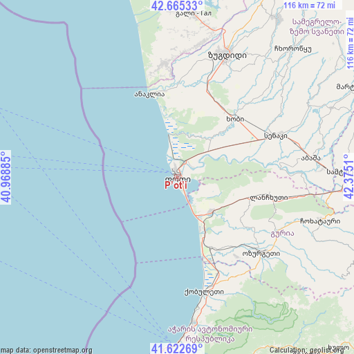
P’ot’i GPS coordinates[2]
42° 8' 46.176" North, 41° 40' 19.092" East
| Map corner | latitude | longitude |
|---|---|---|
| Upper-left | 42.66533°, | 40.96885° |
| Center: | 42.14616°, | 41.67197° |
| Lower-right: | 41.62269°, | 42.3751° |
| Map W x H: | 115.9×115.9 km | = 72×72mi |
| max Lat: | 43.38111° ⇑40.2% North |
| P’ot’i: | 42.14616° |
| min Lat: | ⇓59.8% South 41.21725° |
| min Long | P’ot’i | max Long |
| 40.07944° | 41.67197° | 46.27667° |
| W 12.8%⇐ | ⇒87.2% E |
Elevation
Elevation of P’ot’i is 1 m = 3 ft, and this is 577.8 m = 1896 ft below average elevation for this country.
| Max E: |
2223 m = 7293 ft | 100% |
| Avg. | 578.8 m = 1899 ft | |
| P’ot’i | 1 m = 3 ft | |
Min E: |
1 m = 3 ft | 0% |
See also: P’ot’i elevation on elevation.city.
Geographical zone
P’ot’i is located in North temperate zone (between Tropic of Cancer and the Arctic Circle). Distance of this Northern Tropic circle is 2080.3 km =1292.6 mi to South.| Distance of | km | miles | from P’ot’i |
|---|---|---|---|
| North Pole | 5320.8 | 3306.2 | to North |
| Arctic Circle | 2715 | 1687 | to North |
| Tropic Cancer | 2080.3 | 1292.6 | to South |
| Equator | 4686.2 | 2911.9 | to South |


Nearby cities:
15 places around P’ot’i: (largest is in red/bold)
• Abasha
45.8 km =28.5 mi,  81°
81°
• Chakvi
47.1 km =29.3 mi,  173°
173°
• Khobi
26.5 km =16.5 mi,  44°
44°
• Kobuleti
37.2 km =23.1 mi, 166°
• Kveda Chkhorots’q’u
51 km =31.7 mi, 43°
• Lanchkhuti
30.4 km =18.9 mi,  101°
101°
• Makhinjauri
52.5 km =32.6 mi,  178°
178°
• Naruja
35.4 km =22 mi,  138°
138°
• Ochkhamuri
35.2 km =21.9 mi,  154°
154°
• Orsant’ia
35.8 km =22.2 mi,  0°
0°
• Ozurgeti
37 km =23 mi,  131°
131°
• Senak’i
35.4 km =22 mi,  67°
67°
• Tsikhisdziri
42.8 km =26.6 mi, 170°
• Urek’i
18.9 km =11.7 mi, 152°
• Zugdidi
43.5 km =27 mi,  22°
22°
Sources, notices
• [Note1] Compared only with cities in Georgia existing in our database
• [Src1] Map data: © OpenStreetMap contributors (CC-BY-SA)
• [Src2] Other city data from geonames.org with taken over terms of usage.
• [Src3] Geographical zone / Annual Mean Temperature by Robert A. Rohde @ Wikipedia
