Gori geodata
Gori (Shida Kartli) is a seat of a first-order administrative division; located in Georgia in Asia/Tbilisi (GMT+4) time zone. With population of 46,676 people, there are 7 cities with bigger population in this country. Compared to other cities in Georgia, 53% of cities are located further ↑North; 70.1% of cities are located further ←West and 57.3% of cities have lower elevation than Gori. Note1


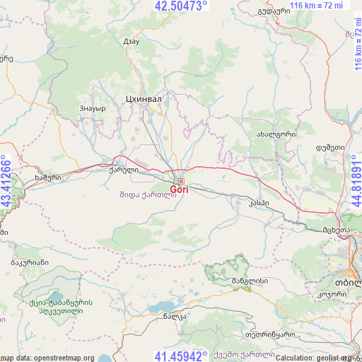
Gori GPS coordinates[2]
41° 59' 3.192" North, 44° 6' 56.808" East
| Map corner | latitude | longitude |
|---|---|---|
| Upper-left | 42.50473°, | 43.41266° |
| Center: | 41.98422°, | 44.11578° |
| Lower-right: | 41.45942°, | 44.81891° |
| Map W x H: | 116.2×116.2 km | = 72.2×72.2mi |
| max Lat: | 43.38111° ⇑53% North |
| Gori: | 41.98422° |
| min Lat: | ⇓47% South 41.21725° |
| min Long | Gori | max Long |
| 40.07944° | 44.11578° | 46.27667° |
| W 70.1%⇐ | ⇒29.9% E |
Elevation
Elevation of Gori is 600 m = 1969 ft, and this is 21.2 m = 70 ft above average elevation for this country.
| Max E: |
2223 m = 7293 ft | 42.7% |
| Gori | 600 m 1969 ft | |
| Avg. | 578.8 m = 1899 ft | |
Min E: |
1 m = 3 ft | 57.3% |
See also: Gori elevation on elevation.city.
Geographical zone
Gori is located in North temperate zone (between Tropic of Cancer and the Arctic Circle). Distance of this Northern Tropic circle is 2062.3 km =1281.5 mi to South.| Distance of | km | miles | from Gori |
|---|---|---|---|
| North Pole | 5338.9 | 3317.4 | to North |
| Arctic Circle | 2733 | 1698.2 | to North |
| Tropic Cancer | 2062.3 | 1281.5 | to South |
| Equator | 4668.2 | 2900.7 | to South |


Nearby cities:
15 places around Gori: (largest is in red/bold)
• Agara
24.8 km =15.4 mi,  283°
283°
• Akhalgori
34.2 km =21.3 mi,  62°
62°
• Dzegvi
43 km =26.7 mi,  110°
110°
• Java
48.5 km =30.1 mi,  342°
342°
• Kaspi
26.5 km =16.5 mi,  104°
104°
• Khashuri
42.6 km =26.5 mi,  271°
271°
• Khet’agurovi
31 km =19.3 mi,  323°
323°
• Manglisi
38.9 km =24.2 mi,  145°
145°
• Samt’avisi
24.5 km =15.2 mi,  83°
83°
• Surami
46.5 km =28.9 mi, 275°
• Tbeti
32 km =19.9 mi,  328°
328°
• Tsalka
43.4 km =27 mi,  182°
182°
• Ts’khinvali
29.7 km =18.5 mi, 335°
• Uplistsikhe
5 km =3.1 mi, 114°
• Znaur
36.6 km =22.7 mi,  309°
309°
Sources, notices
• [Note1] Compared only with cities in Georgia existing in our database
• [Src1] Map data: © OpenStreetMap contributors (CC-BY-SA)
• [Src2] Other city data from geonames.org with taken over terms of usage.
• [Src3] Geographical zone / Annual Mean Temperature by Robert A. Rohde @ Wikipedia
