Khet’agurovi geodata
Khet’agurovi is a populated place; located in Georgia in Asia/Tbilisi (GMT+4) time zone. With population of 850 people, there are 99 cities with bigger population in this country. Compared to other cities in Georgia, 63.2% of cities are located further ↓South; 65.8% of cities are located further ←West and 76.1% of cities have lower elevation than Khet’agurovi. Note1


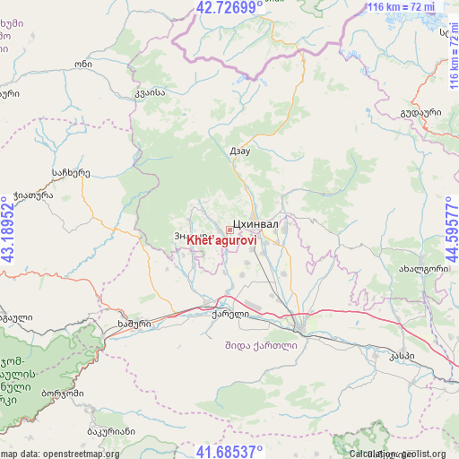
Khet’agurovi GPS coordinates[2]
42° 12' 29.988" North, 43° 53' 33.504" East
| Map corner | latitude | longitude |
|---|---|---|
| Upper-left | 42.72699°, | 43.18952° |
| Center: | 42.20833°, | 43.89264° |
| Lower-right: | 41.68537°, | 44.59577° |
| Map W x H: | 115.8×115.8 km | = 72×72mi |
| max Lat: | 43.38111° ⇑36.8% North |
| Khet’agurovi: | 42.20833° |
| min Lat: | ⇓63.2% South 41.21725° |
| min Long | Khet’agurovi | max Long |
| 40.07944° | 43.89264° | 46.27667° |
| W 65.8%⇐ | ⇒34.2% E |
Elevation
Elevation of Khet’agurovi is 929 m = 3048 ft, and this is 350.2 m = 1149 ft above average elevation for this country.
| Max E: |
2223 m = 7293 ft | 23.9% |
| Khet’agurovi | 929 m 3048 ft | |
| Avg. | 578.8 m = 1899 ft | |
Min E: |
1 m = 3 ft | 76.1% |
See also: Georgia elevation on elevation.city.
Geographical zone
Khet’agurovi is located in North temperate zone (between Tropic of Cancer and the Arctic Circle). Distance of this Northern Tropic circle is 2087.2 km =1296.9 mi to South.| Distance of | km | miles | from Khet’agurovi |
|---|---|---|---|
| North Pole | 5313.9 | 3301.9 | to North |
| Arctic Circle | 2708 | 1682.7 | to North |
| Tropic Cancer | 2087.2 | 1296.9 | to South |
| Equator | 4693.1 | 2916.2 | to South |


Nearby cities:
15 places around Khet’agurovi: (largest is in red/bold)
• Agara
19.8 km =12.3 mi,  196°
196°
• Akhaldaba
45.6 km =28.3 mi,  227°
227°
• Akhalgori
49.5 km =30.8 mi,  100°
100°
• Chiat’ura
49.9 km =31 mi,  281°
281°
• Gori
31 km =19.3 mi,  143°
143°
• Java
21.6 km =13.4 mi,  9°
9°
• Kaspi
54.1 km =33.6 mi,  125°
125°
• Khashuri
33.9 km =21.1 mi, 225°
• Sach’khere
41.8 km =26 mi,  291°
291°
• Samt’avisi
48.2 km =30 mi,  117°
117°
• Surami
34.5 km =21.4 mi, 233°
• Tbeti
2.9 km =1.8 mi,  34°
34°
• Ts’khinvali
6.6 km =4.1 mi,  71°
71°
• Uplistsikhe
35.5 km =22.1 mi, 139°
• Znaur
9.9 km =6.2 mi,  260°
260°
Sources, notices
• [Note1] Compared only with cities in Georgia existing in our database
• [Src1] Map data: © OpenStreetMap contributors (CC-BY-SA)
• [Src2] Other city data from geonames.org with taken over terms of usage.
• [Src3] Geographical zone / Annual Mean Temperature by Robert A. Rohde @ Wikipedia
