P’asanauri geodata
P’asanauri (Mtskheta-Mtianeti) is a populated place; located in Georgia in Asia/Tbilisi (GMT+4) time zone. With population of 2,904 people, there are 74 cities with bigger population in this country. Compared to other cities in Georgia, 73.5% of cities are located further ↓South; 81.2% of cities are located further ←West and 80.3% of cities have lower elevation than P’asanauri. Note1


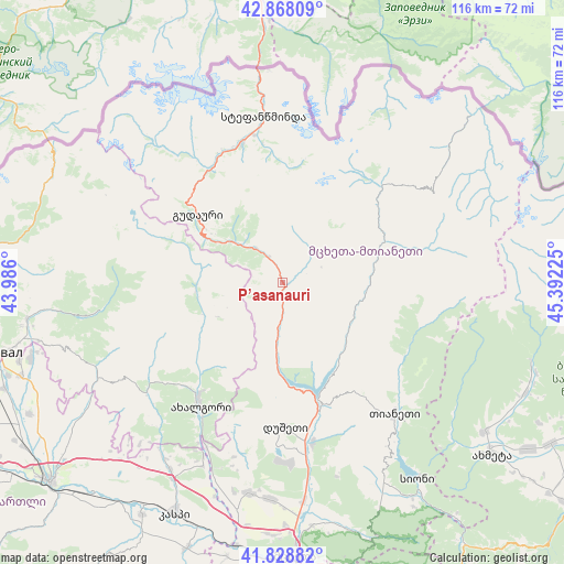
P’asanauri GPS coordinates[2]
42° 21' 2.16" North, 44° 41' 20.832" East
| Map corner | latitude | longitude |
|---|---|---|
| Upper-left | 42.86809°, | 43.986° |
| Center: | 42.3506°, | 44.68912° |
| Lower-right: | 41.82882°, | 45.39225° |
| Map W x H: | 115.6×115.6 km | = 71.8×71.8mi |
| max Lat: | 43.38111° ⇑26.5% North |
| P’asanauri: | 42.3506° |
| min Lat: | ⇓73.5% South 41.21725° |
| min Long | P’asanauri | max Long |
| 40.07944° | 44.68912° | 46.27667° |
| W 81.2%⇐ | ⇒18.8% E |
Elevation
Elevation of P’asanauri is 1070 m = 3510 ft, and this is 491.2 m = 1612 ft above average elevation for this country.
| Max E: |
2223 m = 7293 ft | 19.7% |
| P’asanauri | 1070 m 3510 ft | |
| Avg. | 578.8 m = 1899 ft | |
Min E: |
1 m = 3 ft | 80.3% |
See also: Georgia elevation on elevation.city.
Geographical zone
P’asanauri is located in North temperate zone (between Tropic of Cancer and the Arctic Circle). Distance of this Northern Tropic circle is 2103 km =1306.7 mi to South.| Distance of | km | miles | from P’asanauri |
|---|---|---|---|
| North Pole | 5298.1 | 3292.1 | to North |
| Arctic Circle | 2692.2 | 1672.9 | to North |
| Tropic Cancer | 2103 | 1306.7 | to South |
| Equator | 4708.9 | 2926 | to South |


Nearby cities:
15 places around P’asanauri: (largest is in red/bold)
• Akhalgori
30.2 km =18.8 mi,  214°
214°
• Akhmet’a
55.5 km =34.5 mi,  129°
129°
• Dzegvi
56.6 km =35.2 mi,  187°
187°
• Gudauri
22.5 km =14 mi,  309°
309°
• Java
62 km =38.5 mi,  275°
275°
• Kaspi
52 km =32.3 mi,  204°
204°
• Mtskheta
56.3 km =35 mi,  177°
177°
• Samt’avisi
44.5 km =27.7 mi, 211°
• Sioni
29.9 km =18.6 mi,  343°
343°
• Step’antsminda
34.2 km =21.3 mi,  353°
353°
• Ts’khinvali
60.8 km =37.8 mi,  257°
257°
• T’ianet’i
35.2 km =21.9 mi,  139°
139°
• Uplistsikhe
60.5 km =37.6 mi,  224°
224°
• Zahesi
58.7 km =36.5 mi,  174°
174°
• Zhinvali
25.3 km =15.7 mi,  164°
164°
Sources, notices
• [Note1] Compared only with cities in Georgia existing in our database
• [Src1] Map data: © OpenStreetMap contributors (CC-BY-SA)
• [Src2] Other city data from geonames.org with taken over terms of usage.
• [Src3] Geographical zone / Annual Mean Temperature by Robert A. Rohde @ Wikipedia
