Abasha geodata
Abasha (Samegrelo and Zemo Svaneti) is a populated place; located in Georgia in Asia/Tbilisi (GMT+4) time zone. With population of 6,221 people, there are 48 cities with bigger population in this country. Compared to other cities in Georgia, 64.1% of cities are located further ↓South; 68.4% of cities are located further →East and 82.1% of cities have higher elevation than Abasha. Note1


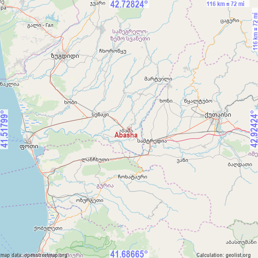
Abasha GPS coordinates[2]
42° 12' 34.524" North, 42° 13' 15.996" East
| Map corner | latitude | longitude |
|---|---|---|
| Upper-left | 42.72824°, | 41.51799° |
| Center: | 42.20959°, | 42.22111° |
| Lower-right: | 41.68665°, | 42.92424° |
| Map W x H: | 115.8×115.8 km | = 72×72mi |
| max Lat: | 43.38111° ⇑35.9% North |
| Abasha: | 42.20959° |
| min Lat: | ⇓64.1% South 41.21725° |
| min Long | Abasha | max Long |
| 40.07944° | 42.22111° | 46.27667° |
| W 31.6%⇐ | ⇒68.4% E |
Elevation
Elevation of Abasha is 26 m = 85 ft, and this is 552.8 m = 1814 ft below average elevation for this country.
| Max E: |
2223 m = 7293 ft | 82.1% |
| Avg. | 578.8 m = 1899 ft | |
| Abasha | 26 m = 85 ft | |
Min E: |
1 m = 3 ft | 17.9% |
See also: Georgia elevation on elevation.city.
Geographical zone
Abasha is located in North temperate zone (between Tropic of Cancer and the Arctic Circle). Distance of this Northern Tropic circle is 2087.3 km =1297 mi to South.| Distance of | km | miles | from Abasha |
|---|---|---|---|
| North Pole | 5313.8 | 3301.8 | to North |
| Arctic Circle | 2707.9 | 1682.6 | to North |
| Tropic Cancer | 2087.3 | 1297 | to South |
| Equator | 4693.3 | 2916.3 | to South |


Nearby cities:
15 places around Abasha: (largest is in red/bold)
• Khobi
29 km =18 mi,  293°
293°
• Khoni
20.7 km =12.9 mi,  52°
52°
• Kutaisi
39.5 km =24.5 mi,  80°
80°
• Kveda Chkhorots’q’u
31.9 km =19.8 mi,  341°
341°
• K’ulashi
10 km =6.2 mi,  93°
93°
• Lanchkhuti
20.4 km =12.7 mi,  229°
229°
• Mart’vili
26.2 km =16.3 mi,  29°
29°
• Naruja
40.2 km =25 mi,  213°
213°
• Ozurgeti
36.3 km =22.6 mi, 209°
• Samtredia
11.3 km =7 mi,  123°
123°
• Senak’i
14.3 km =8.9 mi,  298°
298°
• Tsqaltubo
34.3 km =21.3 mi,  64°
64°
• Urek’i
43.6 km =27.1 mi,  236°
236°
• Vani
28.5 km =17.7 mi, 119°
• Zugdidi
44 km =27.3 mi,  319°
319°
Sources, notices
• [Note1] Compared only with cities in Georgia existing in our database
• [Src1] Map data: © OpenStreetMap contributors (CC-BY-SA)
• [Src2] Other city data from geonames.org with taken over terms of usage.
• [Src3] Geographical zone / Annual Mean Temperature by Robert A. Rohde @ Wikipedia
