Sukuta geodata
Sukuta (Western) is a populated place; located in Gambia in Africa/Banjul (GMT+0) time zone. With population of 15,131 people, there are 6 cities with bigger population in this country. Compared to other cities in Gambia, 65% of cities are located further ↑North; 99.2% of cities are located further →East and 71.5% of cities have lower elevation than Sukuta. Note1


Sukuta GPS coordinates[2]
13° 24' 37.188" North, 16° 42' 29.34" West
| Map corner | latitude | longitude |
|---|---|---|
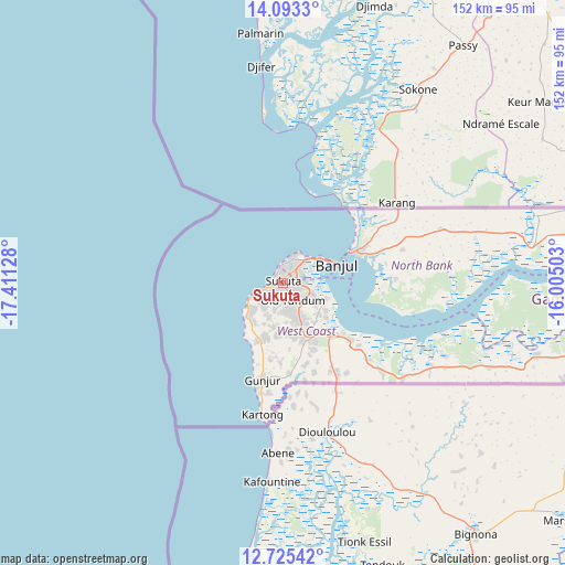
| Upper-left | 14.0933°, | -17.41128° |
| Center: | 13.41033°, | -16.70815° |
| Lower-right: | 12.72542°, | -16.00503° |
| Map W x H: | 152.1×152.1 km | = 94.5×94.5mi |
| max Lat: | 13.8° ⇑65% North |
| Sukuta: | 13.41033° |
| min Lat: | ⇓35% South 13.20194° |
| min Long | Sukuta | max Long |
| -16.73389° | -16.70815° | -13.85° |
| W 0.8%⇐ | ⇒99.2% E |
Elevation
Elevation of Sukuta is 27 m = 89 ft, and this is 5.9 m = 19 ft above average elevation for this country.
| Max E: |
49 m = 161 ft | 28.5% |
| Sukuta | 27 m 89 ft | |
| Avg. | 21.1 m = 69 ft | |
Min E: |
1 m = 3 ft | 71.5% |
See also: Gambia elevation on elevation.city.
Geographical zone
Sukuta is located in North Torrid zone (between Equator and Tropic of Cancer). Distance of this Northern Tropic circle is 1114.8 km =692.7 mi to North.| Distance of | km | miles | from Sukuta |
|---|---|---|---|
| North Pole | 8516 | 5291.6 | to North |
| Arctic Circle | 5910.1 | 3672.4 | to North |
| Tropic Cancer | 1114.8 | 692.7 | to North |
| Equator | 1491.1 | 926.5 | to South |


Nearby cities:
15 places around Sukuta: (largest is in red/bold)
• Abuko
5.7 km =3.5 mi,  96°
96°
• Bakau
8 km =5 mi,  20°
20°
• Banjul
14.8 km =9.2 mi,  71°
71°
• Barra
19.3 km =12 mi, 65°
• Brikama
16.7 km =10.4 mi,  157°
157°
• Chilla
48.5 km =30.1 mi, 71°
• Essau
20.5 km =12.7 mi, 66°
• Gunjur
23.3 km =14.5 mi,  186°
186°
• Janneh Kunda
61.7 km =38.3 mi,  93°
93°
• Kerewan
67.6 km =42 mi,  82°
82°
• Lamin
30.4 km =18.9 mi, 102°
• Medina Kanuma
22 km =13.7 mi, 65°
• Serekunda
4.5 km =2.8 mi,  46°
46°
• Somita
49.1 km =30.5 mi,  117°
117°
• Tambana
58.7 km =36.5 mi, 79°
Sources, notices
• [Note1] Compared only with cities in Gambia existing in our database
• [Src1] Map data: © OpenStreetMap contributors (CC-BY-SA)
• [Src2] Other city data from geonames.org with taken over terms of usage.
• [Src3] Geographical zone / Annual Mean Temperature by Robert A. Rohde @ Wikipedia
