Somita geodata
Somita (Western) is a populated place; located in Gambia in Africa/Banjul (GMT+0) time zone. With population of 2,541 people, there are 23 cities with bigger population in this country. Compared to other cities in Gambia, 99.2% of cities are located further ↑North; 91.1% of cities are located further →East and 71.5% of cities have lower elevation than Somita. Note1


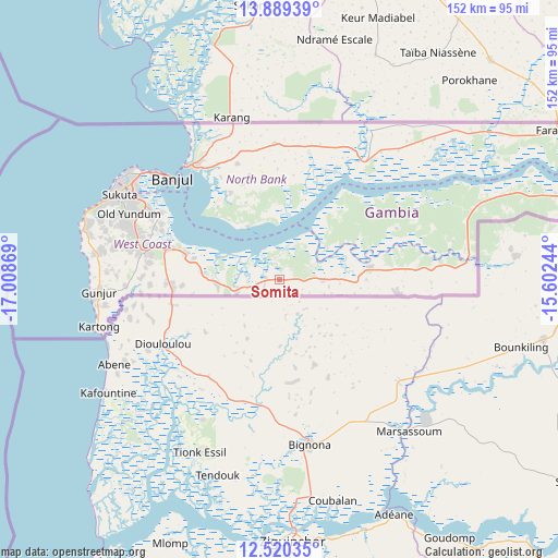
Somita GPS coordinates[2]
13° 12' 20.988" North, 16° 18' 20.016" West
| Map corner | latitude | longitude |
|---|---|---|
| Upper-left | 13.88939°, | -17.00869° |
| Center: | 13.20583°, | -16.30556° |
| Lower-right: | 12.52035°, | -15.60244° |
| Map W x H: | 152.2×152.2 km | = 94.6×94.6mi |
| max Lat: | 13.8° ⇑99.2% North |
| Somita: | 13.20583° |
| min Lat: | ⇓0.8% South 13.20194° |
| min Long | Somita | max Long |
| -16.73389° | -16.30556° | -13.85° |
| W 8.9%⇐ | ⇒91.1% E |
Elevation
Elevation of Somita is 27 m = 89 ft, and this is 5.9 m = 19 ft above average elevation for this country.
| Max E: |
49 m = 161 ft | 28.5% |
| Somita | 27 m 89 ft | |
| Avg. | 21.1 m = 69 ft | |
Min E: |
1 m = 3 ft | 71.5% |
See also: Gambia elevation on elevation.city.
Geographical zone
Somita is located in North Torrid zone (between Equator and Tropic of Cancer). Distance of this Northern Tropic circle is 1137.6 km =706.9 mi to North.| Distance of | km | miles | from Somita |
|---|---|---|---|
| North Pole | 8538.7 | 5305.7 | to North |
| Arctic Circle | 5932.8 | 3686.5 | to North |
| Tropic Cancer | 1137.6 | 706.9 | to North |
| Equator | 1468.4 | 912.4 | to South |


Nearby cities:
15 places around Somita: (largest is in red/bold)
• Banjul
40.3 km =25 mi,  312°
312°
• Barra
40.3 km =25 mi,  319°
319°
• Brikama
37.9 km =23.5 mi,  281°
281°
• Chilla
38.3 km =23.8 mi,  3°
3°
• Essau
39.6 km =24.6 mi, 321°
• Jali
40 km =24.9 mi,  66°
66°
• Janneh Kunda
26.5 km =16.5 mi,  43°
43°
• Keneba
34.3 km =21.3 mi, 66°
• Kerewan
39.3 km =24.4 mi, 36°
• Kinteh Kunda
42.3 km =26.3 mi, 37°
• Lamin
21.4 km =13.3 mi, 319°
• Mayork
36.8 km =22.9 mi,  85°
85°
• Medina Kanuma
39.7 km =24.7 mi, 323°
• Tambana
36.2 km =22.5 mi,  23°
23°
• Tankular
37.4 km =23.2 mi,  50°
50°
Sources, notices
• [Note1] Compared only with cities in Gambia existing in our database
• [Src1] Map data: © OpenStreetMap contributors (CC-BY-SA)
• [Src2] Other city data from geonames.org with taken over terms of usage.
• [Src3] Geographical zone / Annual Mean Temperature by Robert A. Rohde @ Wikipedia
