Brikama geodata
Brikama (Western) is a seat of a first-order administrative division; located in Gambia in Africa/Banjul (GMT+0) time zone. With population of 77,700 people, there is 1 city with bigger population in this country. Compared to other cities in Gambia, 92.7% of cities are located further ↑North; 95.9% of cities are located further →East and 64.2% of cities have lower elevation than Brikama. Note1


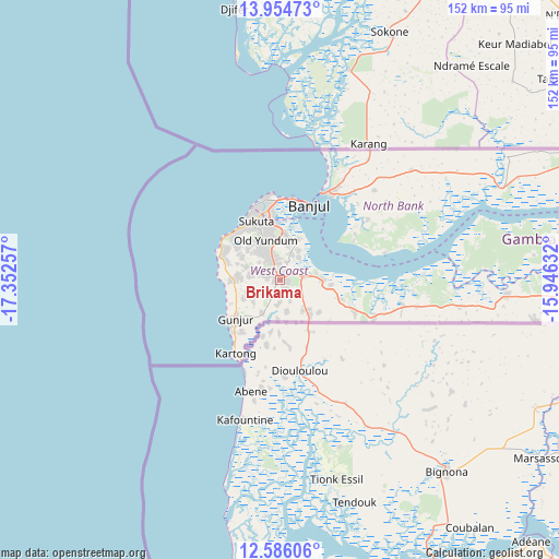
Brikama GPS coordinates[2]
13° 16' 16.896" North, 16° 38' 57.984" West
| Map corner | latitude | longitude |
|---|---|---|
| Upper-left | 13.95473°, | -17.35257° |
| Center: | 13.27136°, | -16.64944° |
| Lower-right: | 12.58606°, | -15.94632° |
| Map W x H: | 152.2×152.2 km | = 94.6×94.6mi |
| max Lat: | 13.8° ⇑92.7% North |
| Brikama: | 13.27136° |
| min Lat: | ⇓7.3% South 13.20194° |
| min Long | Brikama | max Long |
| -16.73389° | -16.64944° | -13.85° |
| W 4.1%⇐ | ⇒95.9% E |
Elevation
Elevation of Brikama is 24 m = 79 ft, and this is 2.9 m = 10 ft above average elevation for this country.
| Max E: |
49 m = 161 ft | 35.8% |
| Brikama | 24 m 79 ft | |
| Avg. | 21.1 m = 69 ft | |
Min E: |
1 m = 3 ft | 64.2% |
See also: Brikama elevation on elevation.city.
Geographical zone
Brikama is located in North Torrid zone (between Equator and Tropic of Cancer). Distance of this Northern Tropic circle is 1130.3 km =702.3 mi to North.| Distance of | km | miles | from Brikama |
|---|---|---|---|
| North Pole | 8531.4 | 5301.2 | to North |
| Arctic Circle | 5925.5 | 3681.9 | to North |
| Tropic Cancer | 1130.3 | 702.3 | to North |
| Equator | 1475.6 | 916.9 | to South |


Nearby cities:
15 places around Brikama: (largest is in red/bold)
• Abuko
14.8 km =9.2 mi,  357°
357°
• Bakau
23.3 km =14.5 mi,  351°
351°
• Banjul
21.6 km =13.4 mi,  20°
20°
• Barra
26.1 km =16.2 mi,  25°
25°
• Chilla
50.3 km =31.3 mi,  51°
51°
• Essau
26.7 km =16.6 mi, 27°
• Gunjur
12 km =7.5 mi,  229°
229°
• Janneh Kunda
56.6 km =35.2 mi,  77°
77°
• Kerewan
65.3 km =40.6 mi,  68°
68°
• Lamin
25 km =15.5 mi, 68°
• Medina Kanuma
28.1 km =17.5 mi, 28°
• Serekunda
18.8 km =11.7 mi, 350°
• Somita
37.9 km =23.5 mi,  101°
101°
• Sukuta
16.7 km =10.4 mi,  337°
337°
• Tambana
57.6 km =35.8 mi,  63°
63°
Sources, notices
• [Note1] Compared only with cities in Gambia existing in our database
• [Src1] Map data: © OpenStreetMap contributors (CC-BY-SA)
• [Src2] Other city data from geonames.org with taken over terms of usage.
• [Src3] Geographical zone / Annual Mean Temperature by Robert A. Rohde @ Wikipedia
