Lamin geodata
Lamin (North Bank) is a populated place; located in Gambia in Africa/Banjul (GMT+0) time zone. With population of 24,797 people, there are 5 cities with bigger population in this country. Compared to other cities in Gambia, 78.9% of cities are located further ↑North; 91.9% of cities are located further →East and 70.7% of cities have higher elevation than Lamin. Note1


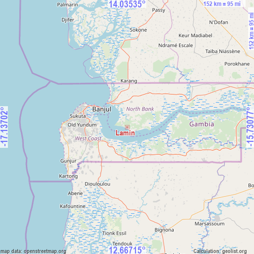
Lamin GPS coordinates[2]
13° 21' 7.992" North, 16° 26' 2.004" West
| Map corner | latitude | longitude |
|---|---|---|
| Upper-left | 14.03535°, | -17.13702° |
| Center: | 13.35222°, | -16.43389° |
| Lower-right: | 12.66715°, | -15.73077° |
| Map W x H: | 152.1×152.1 km | = 94.5×94.5mi |
| max Lat: | 13.8° ⇑78.9% North |
| Lamin: | 13.35222° |
| min Lat: | ⇓21.1% South 13.20194° |
| min Long | Lamin | max Long |
| -16.73389° | -16.43389° | -13.85° |
| W 8.1%⇐ | ⇒91.9% E |
Elevation
Elevation of Lamin is 15 m = 49 ft, and this is 6.1 m = 20 ft below average elevation for this country.
| Max E: |
49 m = 161 ft | 70.7% |
| Avg. | 21.1 m = 69 ft | |
| Lamin | 15 m = 49 ft | |
Min E: |
1 m = 3 ft | 29.3% |
See also: Gambia elevation on elevation.city.
Geographical zone
Lamin is located in North Torrid zone (between Equator and Tropic of Cancer). Distance of this Northern Tropic circle is 1121.3 km =696.7 mi to North.| Distance of | km | miles | from Lamin |
|---|---|---|---|
| North Pole | 8522.4 | 5295.6 | to North |
| Arctic Circle | 5916.5 | 3676.3 | to North |
| Tropic Cancer | 1121.3 | 696.7 | to North |
| Equator | 1484.6 | 922.5 | to South |


Nearby cities:
15 places around Lamin: (largest is in red/bold)
• Abuko
24.7 km =15.3 mi,  283°
283°
• Bakau
30.3 km =18.8 mi,  297°
297°
• Banjul
19.2 km =11.9 mi,  305°
305°
• Barra
18.9 km =11.7 mi,  320°
320°
• Brikama
25 km =15.5 mi,  248°
248°
• Chilla
27.4 km =17 mi,  36°
36°
• Essau
18.3 km =11.4 mi, 323°
• Gunjur
36.5 km =22.7 mi,  242°
242°
• Janneh Kunda
32.1 km =19.9 mi,  84°
84°
• Kerewan
40.3 km =25 mi,  67°
67°
• Medina Kanuma
18.4 km =11.4 mi,  328°
328°
• Serekunda
28.1 km =17.5 mi,  289°
289°
• Somita
21.4 km =13.3 mi,  139°
139°
• Sukuta
30.4 km =18.9 mi, 282°
• Tambana
32.8 km =20.4 mi,  58°
58°
Sources, notices
• [Note1] Compared only with cities in Gambia existing in our database
• [Src1] Map data: © OpenStreetMap contributors (CC-BY-SA)
• [Src2] Other city data from geonames.org with taken over terms of usage.
• [Src3] Geographical zone / Annual Mean Temperature by Robert A. Rohde @ Wikipedia
