Essau geodata
Essau (North Bank) is a populated place; located in Gambia in Africa/Banjul (GMT+0) time zone. With population of 5,907 people, there are 13 cities with bigger population in this country. Compared to other cities in Gambia, 60.2% of cities are located further ↓South; 93.5% of cities are located further →East and 78.9% of cities have higher elevation than Essau. Note1


Essau GPS coordinates[2]
13° 29' 2.004" North, 16° 32' 4.992" West
| Map corner | latitude | longitude |
|---|---|---|
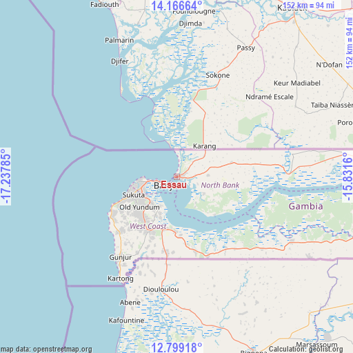
| Upper-left | 14.16664°, | -17.23785° |
| Center: | 13.48389°, | -16.53472° |
| Lower-right: | 12.79918°, | -15.8316° |
| Map W x H: | 152×152.1 km | = 94.4×94.5mi |
| max Lat: | 13.8° ⇑39.8% North |
| Essau: | 13.48389° |
| min Lat: | ⇓60.2% South 13.20194° |
| min Long | Essau | max Long |
| -16.73389° | -16.53472° | -13.85° |
| W 6.5%⇐ | ⇒93.5% E |
Elevation
Elevation of Essau is 12 m = 39 ft, and this is 9.1 m = 30 ft below average elevation for this country.
| Max E: |
49 m = 161 ft | 78.9% |
| Avg. | 21.1 m = 69 ft | |
| Essau | 12 m = 39 ft | |
Min E: |
1 m = 3 ft | 21.1% |
See also: Gambia elevation on elevation.city.
Geographical zone
Essau is located in North Torrid zone (between Equator and Tropic of Cancer). Distance of this Northern Tropic circle is 1106.7 km =687.7 mi to North.| Distance of | km | miles | from Essau |
|---|---|---|---|
| North Pole | 8507.8 | 5286.5 | to North |
| Arctic Circle | 5901.9 | 3667.3 | to North |
| Tropic Cancer | 1106.7 | 687.7 | to North |
| Equator | 1499.3 | 931.6 | to South |


Nearby cities:
15 places around Essau: (largest is in red/bold)
• Abuko
15.8 km =9.8 mi,  235°
235°
• Bakau
15.9 km =9.9 mi,  267°
267°
• Banjul
5.8 km =3.6 mi,  233°
233°
• Barra
1.2 km =0.7 mi,  263°
263°
• Brikama
26.7 km =16.6 mi,  207°
207°
• Chilla
28.2 km =17.5 mi,  74°
74°
• Gunjur
38 km =23.6 mi, 214°
• Janneh Kunda
44.4 km =27.6 mi,  105°
105°
• Kerewan
48.2 km =30 mi,  89°
89°
• Lamin
18.3 km =11.4 mi,  143°
143°
• Medina Kanuma
1.6 km =1 mi,  51°
51°
• Serekunda
16.3 km =10.1 mi,  251°
251°
• Somita
39.6 km =24.6 mi, 141°
• Sukuta
20.5 km =12.7 mi, 246°
• Tambana
39 km =24.2 mi, 86°
Sources, notices
• [Note1] Compared only with cities in Gambia existing in our database
• [Src1] Map data: © OpenStreetMap contributors (CC-BY-SA)
• [Src2] Other city data from geonames.org with taken over terms of usage.
• [Src3] Geographical zone / Annual Mean Temperature by Robert A. Rohde @ Wikipedia
