Karellás geodata
Karellás (Attica) is a populated place; located in Greece in Europe/Athens (GMT+3) time zone. With population of 1,579 people, there are 627 cities with bigger population in this country. Compared to other cities in Greece, 76.6% of cities are located further ↑North; 75.1% of cities are located further ←West and 63.6% of cities have lower elevation than Karellás. Note1
Administrative division(s):
- Level 1: Attica
- Level 2: Nomarchía Anatolikís Attikís
- Level 3: Dimos Kropia


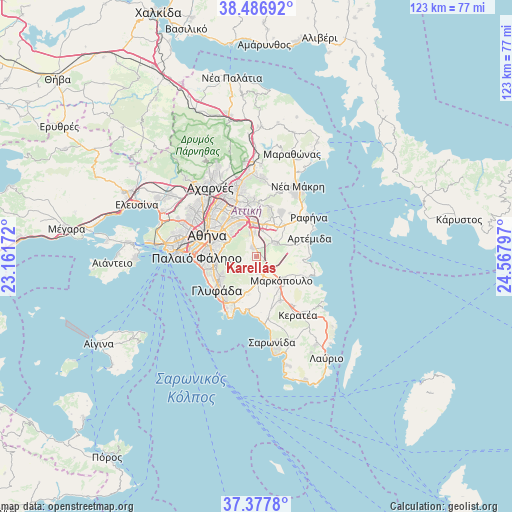
Karellás GPS coordinates[2]
37° 56' 4.02" North, 23° 51' 53.424" East
| Map corner | latitude | longitude |
|---|---|---|
| Upper-left | 38.48692°, | 23.16172° |
| Center: | 37.93445°, | 23.86484° |
| Lower-right: | 37.3778°, | 24.56797° |
| Map W x H: | 123.3×123.3 km | = 76.6×76.6mi |
| max Lat: | 41.72048° ⇑76.6% North |
| Karellás: | 37.93445° |
| min Lat: | ⇓23.4% South 34.8346° |
| min Long | Karellás | max Long |
| 19.40494° | 23.86484° | 29.59361° |
| W 75.1%⇐ | ⇒24.9% E |
Elevation
Elevation of Karellás is 134 m = 440 ft, and this is 34.9 m = 115 ft below average elevation for this country.
| Max E: |
1439 m = 4721 ft | 36.4% |
| Avg. | 168.9 m = 554 ft | |
| Karellás | 134 m = 440 ft | |
Min E: |
0 m = 0 ft | 63.6% |
See also: Greece elevation on elevation.city.
Geographical zone
Karellás is located in North temperate zone (between Tropic of Cancer and the Arctic Circle). Distance of this Northern Tropic circle is 1612 km =1001.7 mi to South.| Distance of | km | miles | from Karellás |
|---|---|---|---|
| North Pole | 5789.1 | 3597.2 | to North |
| Arctic Circle | 3183.3 | 1978 | to North |
| Tropic Cancer | 1612 | 1001.7 | to South |
| Equator | 4217.9 | 2620.9 | to South |


Nearby cities:
15 places around Karellás: (largest is in red/bold)
• Agía Paraskeví
9.6 km =6 mi,  343°
343°
• Argithéa
4.9 km =3 mi,  21°
21°
• Cholargós
9.2 km =5.7 mi,  322°
322°
• Christoúpoli
6.7 km =4.2 mi,  43°
43°
• Ilioúpoli
8.5 km =5.3 mi,  267°
267°
• Kaisarianí
9.3 km =5.8 mi,  290°
290°
• Koropí
4 km =2.5 mi,  171°
171°
• Kítsi
9.4 km =5.8 mi,  192°
192°
• Leondárion
5.9 km =3.7 mi,  351°
351°
• Markópoulo
8.3 km =5.2 mi,  133°
133°
• Paianía
2.5 km =1.6 mi, 338°
• Pallíni
8 km =5 mi,  11°
11°
• Papágou
8.5 km =5.3 mi,  312°
312°
• Spáta
5.3 km =3.3 mi,  55°
55°
• Zográfos
9.6 km =6 mi,  298°
298°
Sources, notices
• [Note1] Compared only with cities in Greece existing in our database
• [Src1] Map data: © OpenStreetMap contributors (CC-BY-SA)
• [Src2] Other city data from geonames.org with taken over terms of usage.
• [Src3] Geographical zone / Annual Mean Temperature by Robert A. Rohde @ Wikipedia
