Vlycháda geodata
Vlycháda (Attica) is a populated place; located in Greece in Europe/Athens (GMT+3) time zone. With population of 1,462 people, there are 682 cities with bigger population in this country. Compared to other cities in Greece, 72.4% of cities are located further ↑North; 63% of cities are located further ←West and 50.3% of cities have higher elevation than Vlycháda. Note1
Administrative division(s):
- Level 1: Attica
- Level 2: Nomarchía Dytikís Attikís
- Level 3: Dimos Megara


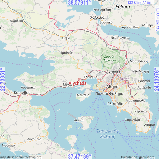
Vlycháda GPS coordinates[2]
38° 1' 38.424" North, 23° 26' 11.868" East
| Map corner | latitude | longitude |
|---|---|---|
| Upper-left | 38.57911°, | 22.73351° |
| Center: | 38.02734°, | 23.43663° |
| Lower-right: | 37.47139°, | 24.13976° |
| Map W x H: | 123.2×123.2 km | = 76.6×76.6mi |
| max Lat: | 41.72048° ⇑72.4% North |
| Vlycháda: | 38.02734° |
| min Lat: | ⇓27.6% South 34.8346° |
| min Long | Vlycháda | max Long |
| 19.40494° | 23.43663° | 29.59361° |
| W 63%⇐ | ⇒37% E |
Elevation
Elevation of Vlycháda is 80 m = 262 ft, and this is 88.9 m = 292 ft below average elevation for this country.
| Max E: |
1439 m = 4721 ft | 50.3% |
| Avg. | 168.9 m = 554 ft | |
| Vlycháda | 80 m = 262 ft | |
Min E: |
0 m = 0 ft | 49.7% |
See also: Greece elevation on elevation.city.
Geographical zone
Vlycháda is located in North temperate zone (between Tropic of Cancer and the Arctic Circle). Distance of this Northern Tropic circle is 1622.3 km =1008.1 mi to South.| Distance of | km | miles | from Vlycháda |
|---|---|---|---|
| North Pole | 5778.8 | 3590.8 | to North |
| Arctic Circle | 3172.9 | 1971.5 | to North |
| Tropic Cancer | 1622.3 | 1008.1 | to South |
| Equator | 4228.2 | 2627.3 | to South |


Nearby cities:
15 places around Vlycháda: (largest is in red/bold)
• Aiánteio
11.9 km =7.4 mi,  170°
170°
• Ampelákia
11.7 km =7.3 mi,  136°
136°
• Asprópyrgos
13.9 km =8.6 mi,  74°
74°
• Elefsína
9.4 km =5.8 mi,  80°
80°
• Lákka Kalogírou
5.8 km =3.6 mi,  230°
230°
• Magoúla
9.4 km =5.8 mi,  51°
51°
• Mándra
7.1 km =4.4 mi, 51°
• Mégara
8.9 km =5.5 mi,  246°
246°
• Néa Péramos
2.6 km =1.6 mi,  206°
206°
• Néa Zoí
7.5 km =4.7 mi,  33°
33°
• Páchi
8.7 km =5.4 mi, 228°
• Pérama
13.6 km =8.5 mi,  119°
119°
• Salamína
8.8 km =5.5 mi, 143°
• Selínia
13.4 km =8.3 mi, 141°
• Skarmagkás
14.7 km =9.1 mi,  96°
96°
Sources, notices
• [Note1] Compared only with cities in Greece existing in our database
• [Src1] Map data: © OpenStreetMap contributors (CC-BY-SA)
• [Src2] Other city data from geonames.org with taken over terms of usage.
• [Src3] Geographical zone / Annual Mean Temperature by Robert A. Rohde @ Wikipedia
