Sperchógeia geodata
Sperchógeia (Peloponnese) is a populated place; located in Greece in Europe/Athens (GMT+3) time zone. With population of 1,004 people, there are 1010 cities with bigger population in this country. Compared to other cities in Greece, 89.2% of cities are located further ↑North; 70.6% of cities are located further →East and 58.7% of cities have higher elevation than Sperchógeia. Note1


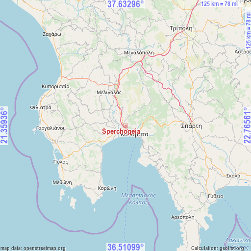
Sperchógeia GPS coordinates[2]
37° 4' 26.58" North, 22° 3' 44.928" East
| Map corner | latitude | longitude |
|---|---|---|
| Upper-left | 37.63296°, | 21.35936° |
| Center: | 37.07405°, | 22.06248° |
| Lower-right: | 36.51099°, | 22.76561° |
| Map W x H: | 124.8×124.8 km | = 77.5×77.5mi |
| max Lat: | 41.72048° ⇑89.2% North |
| Sperchógeia: | 37.07405° |
| min Lat: | ⇓10.8% South 34.8346° |
| min Long | Sperchógeia | max Long |
| 19.40494° | 22.06248° | 29.59361° |
| W 29.4%⇐ | ⇒70.6% E |
Elevation
Elevation of Sperchógeia is 54 m = 177 ft, and this is 114.9 m = 377 ft below average elevation for this country.
| Max E: |
1439 m = 4721 ft | 58.7% |
| Avg. | 168.9 m = 554 ft | |
| Sperchógeia | 54 m = 177 ft | |
Min E: |
0 m = 0 ft | 41.3% |
See also: Greece elevation on elevation.city.
Geographical zone
Sperchógeia is located in North temperate zone (between Tropic of Cancer and the Arctic Circle). Distance of this Northern Tropic circle is 1516.3 km =942.2 mi to South.| Distance of | km | miles | from Sperchógeia |
|---|---|---|---|
| North Pole | 5884.8 | 3656.6 | to North |
| Arctic Circle | 3278.9 | 2037.4 | to North |
| Tropic Cancer | 1516.3 | 942.2 | to South |
| Equator | 4122.2 | 2561.4 | to South |


Nearby cities:
15 places around Sperchógeia: (largest is in red/bold)
• Arfará
9.3 km =5.8 mi,  350°
350°
• Asprókhoma
3.1 km =1.9 mi,  159°
159°
• Kalamata
5.9 km =3.7 mi,  131°
131°
• Kardamýli
25.7 km =16 mi,  143°
143°
• Laíika
3.3 km =2.1 mi,  114°
114°
• Longá
26.7 km =16.6 mi,  211°
211°
• Meligalás
18 km =11.2 mi,  331°
331°
• Messíni
5.5 km =3.4 mi,  242°
242°
• Mikrománi
2.7 km =1.7 mi,  277°
277°
• Mikrá Mantíneia
12.7 km =7.9 mi, 140°
• Paralía Vérgas
11.2 km =7 mi, 131°
• Thouría
1.6 km =1 mi,  311°
311°
• Valýra
12.4 km =7.7 mi,  324°
324°
• Vlachópoulo
24.5 km =15.2 mi,  258°
258°
• Áris
5.9 km =3.7 mi,  298°
298°
Sources, notices
• [Note1] Compared only with cities in Greece existing in our database
• [Src1] Map data: © OpenStreetMap contributors (CC-BY-SA)
• [Src2] Other city data from geonames.org with taken over terms of usage.
• [Src3] Geographical zone / Annual Mean Temperature by Robert A. Rohde @ Wikipedia
