Meligalás geodata
Meligalás (Peloponnese) is a seat of a third-order administrative division; located in Greece in Europe/Athens (GMT+3) time zone. With population of 1,431 people, there are 702 cities with bigger population in this country. Compared to other cities in Greece, 88% of cities are located further ↑North; 73% of cities are located further →East and 50.3% of cities have lower elevation than Meligalás. Note1


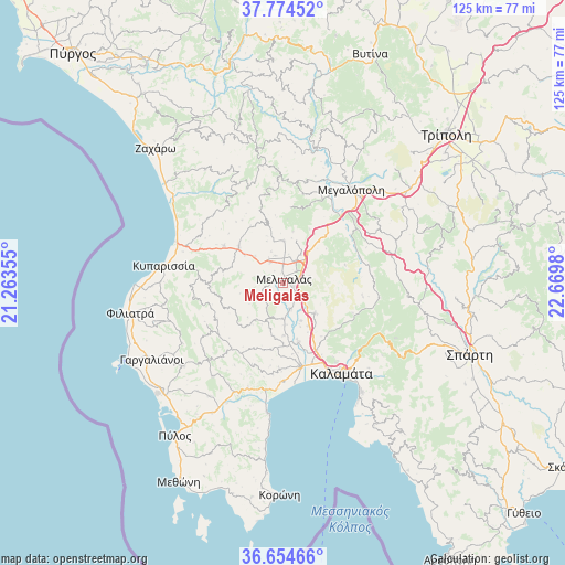
Meligalás GPS coordinates[2]
37° 13' 0.012" North, 21° 58' 0.012" East
| Map corner | latitude | longitude |
|---|---|---|
| Upper-left | 37.77452°, | 21.26355° |
| Center: | 37.21667°, | 21.96667° |
| Lower-right: | 36.65466°, | 22.6698° |
| Map W x H: | 124.5×124.5 km | = 77.4×77.4mi |
| max Lat: | 41.72048° ⇑88% North |
| Meligalás: | 37.21667° |
| min Lat: | ⇓12% South 34.8346° |
| min Long | Meligalás | max Long |
| 19.40494° | 21.96667° | 29.59361° |
| W 27%⇐ | ⇒73% E |
Elevation
Elevation of Meligalás is 82 m = 269 ft, and this is 86.9 m = 285 ft below average elevation for this country.
| Max E: |
1439 m = 4721 ft | 49.7% |
| Avg. | 168.9 m = 554 ft | |
| Meligalás | 82 m = 269 ft | |
Min E: |
0 m = 0 ft | 50.3% |
See also: Greece elevation on elevation.city.
Geographical zone
Meligalás is located in North temperate zone (between Tropic of Cancer and the Arctic Circle). Distance of this Northern Tropic circle is 1532.2 km =952.1 mi to South.| Distance of | km | miles | from Meligalás |
|---|---|---|---|
| North Pole | 5869 | 3646.8 | to North |
| Arctic Circle | 3263.1 | 2027.6 | to North |
| Tropic Cancer | 1532.2 | 952.1 | to South |
| Equator | 4138.1 | 2571.3 | to South |


Nearby cities:
15 places around Meligalás: (largest is in red/bold)
• Arfará
9.7 km =6 mi,  134°
134°
• Asprókhoma
21.1 km =13.1 mi,  152°
152°
• Kalamata
23.6 km =14.7 mi, 146°
• Kopanáki
15.4 km =9.6 mi,  301°
301°
• Kyparissía
26.2 km =16.3 mi,  278°
278°
• Laíika
20.7 km =12.9 mi, 146°
• Megalópoli
25.7 km =16 mi,  37°
37°
• Messíni
18.8 km =11.7 mi,  168°
168°
• Mikrománi
16.6 km =10.3 mi,  159°
159°
• Paralía Vérgas
28.8 km =17.9 mi,  144°
144°
• Sperchógeia
18 km =11.2 mi, 151°
• Thouría
16.5 km =10.3 mi, 153°
• Valýra
5.8 km =3.6 mi, 166°
• Vlachópoulo
25.8 km =16 mi,  217°
217°
• Áris
13.5 km =8.4 mi, 165°
Sources, notices
• [Note1] Compared only with cities in Greece existing in our database
• [Src1] Map data: © OpenStreetMap contributors (CC-BY-SA)
• [Src2] Other city data from geonames.org with taken over terms of usage.
• [Src3] Geographical zone / Annual Mean Temperature by Robert A. Rohde @ Wikipedia
